Category:1890s maps of Austria-Hungary
Jump to navigation
Jump to search
Subcategories
This category has the following 7 subcategories, out of 7 total.
- 1893 maps of Austria-Hungary (empty)
- 1896 maps of Austria-Hungary (3 F)
- 1897 maps of Austria-Hungary (4 F)
- 1898 maps of Austria-Hungary (8 F)
.
Media in category "1890s maps of Austria-Hungary"
The following 31 files are in this category, out of 31 total.
-
 1. Bezirk - Plan der Reichshaupt - & Residenzstadt Wien von Gustav Freytag (cropped).jpg 4,680 × 4,745; 6.01 MB
-
 Ptuj BV043901181.jpg 12,406 × 9,104; 22.99 MB
-

-
-
 Meyers leiner Hand-atlas 1893 (73136699).jpg 9,523 × 6,378; 11.8 MB
-

-
 Orosháza BV043905858.jpg 14,404 × 11,102; 19.91 MB
-
 Brockhaus 1894 Deutsche Mundarten.jpg 3,551 × 2,866; 1.17 MB
-

-
-
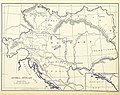
 Austria-Hungary (ethnic).JPG 5,150 × 3,395; 4.73 MB
-
 Plan der Reichshaupt - & Residenzstadt Wien von Gustav Freytag.jpg 19,337 × 16,464; 87.12 MB
-
 Saybusch BV035874780.jpg 9,888 × 7,980; 12.52 MB
-
 Stará L'ubovňa BV035879314.jpg 8,179 × 6,893; 11.11 MB
-
 Rimavská Sobota BV035894954.jpg 10,002 × 7,792; 11.38 MB
-
 Rožňava BV035893962.jpg 9,786 × 7,888; 12.35 MB
-

-
 35 of 'Arnold's Geographical Handbooks' (11288556586).jpg 1,226 × 1,173; 462 KB
-
 Blaj BV043904051.jpg 14,406 × 11,102; 31.46 MB
-
 Dumbrăveni (Hermannstadt) BV043904714.jpg 14,406 × 11,102; 32.98 MB
-
 Kežmarok BV035880377.jpg 10,014 × 7,864; 12.35 MB
-
 Spišská Nová Ves BV035880584.jpg 9,990 × 7,792; 12.68 MB
-
 Trnava BV035894188.jpg 10,050 × 7,888; 9.74 MB
-
 Judeţ Mureş BV043902537.jpg 12,446 × 9,120; 25.99 MB
-

-

-

-

-
 Eger (Komitat Heves) BV035904849.jpg 8,262 × 6,294; 9.53 MB
-
 Stielers Handatlas 1891 17.jpg 5,100 × 4,250; 7.39 MB
-
 Stielers Handatlas 1891 18.jpg 5,100 × 4,250; 8.47 MB
.jpg)

.jpg)
.jpg)
.jpg)
.jpg)


%27_(11232150423).jpg)
.JPG)


.jpg)
.jpg)

_BV043904714.jpg)


_oszt%C3%A1ly_sz%C3%A1mara_..._t%C3%A9rk%C3%A9ppel%27_(11294122583).jpg)
.jpg)
_oszt%C3%A1ly_sz%C3%A1mara_..._t%C3%A9rk%C3%A9ppel%27_(11204619494).jpg)
_oszt%C3%A1ly_sz%C3%A1mara._(With_maps.)%27_(11206473754).jpg)
_BV035904849.jpg)

