Category:18th-century maps of Philadelphia
Jump to navigation
Jump to search
Maps of Philadelphia by century: (BCE) (CE) 17th century · 18th century · 19th century · 20th century · 21st century ·
Subcategories
This category has the following 5 subcategories, out of 5 total.
Media in category "18th-century maps of Philadelphia"
The following 5 files are in this category, out of 5 total.
-
 A Plan of the city of Philadelphia - btv1b530897081.jpg 7,984 × 5,824; 7.84 MB
-
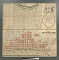
 City of Philadelphia, Original Division into 10 Wards.jpg 574 × 392; 76 KB
-
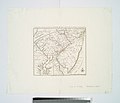
 Dock Creek.png 750 × 621; 984 KB
-
-


.jpg)
.jpg)