Category:1904 maps of Europe
Jump to navigation
Jump to search
Temperate regions: North America · South America · Africa · Europe · Asia · – Polar regions: – Other regions:
English: 1904 maps of Europe
Español: Mapas de Europa en 1904
Suomi: Euroopan kartat vuodelta 1904
Română: Hărți ale Europei din 1904
Subcategories
This category has the following 9 subcategories, out of 9 total.
.
G
N
- 1904 maps of Norway (78 F)
P
S
- 1904 maps of Spain (1 F)
- 1904 maps of Switzerland (6 F)
T
U
- 1904 maps of Ukraine (3 F)
Media in category "1904 maps of Europe"
The following 11 files are in this category, out of 11 total.
-
 Mitteleuropa – Konfessionsgebiete 1904.jpg 5,755 × 4,145; 15.12 MB
-
 Mitteleuropa – Völker u. Sprachgebiete.jpg 5,613 × 4,147; 15.16 MB
-
 1904 Haru EiDo Serio-Comic Map of Asia and Europe during the Russo-Japanese War.jpg 6,000 × 4,268; 7.56 MB
-
 1904 Kisaburō Ohara Satirical Octopus Map of Asia and Europe.jpg 6,000 × 4,488; 6.63 MB
-
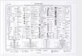 Abkürzungsverzeichnis, Zeichenschlüssel der Spezialkarte.jpg 8,268 × 5,656; 6.18 MB
-
 Arkiv för botanik (1904) (14800326843).jpg 3,264 × 2,042; 940 KB
-
 Correzione confini Milano Greco Milanese 1904.png 527 × 729; 733 KB
-

-
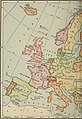 Modern history; Europe (1904) (14765537282).jpg 2,068 × 3,004; 1.96 MB
-
 Modern history; Europe (1904) (14765804245).jpg 1,984 × 1,256; 716 KB
-
 Modern history; Europe (1904) (14785728903).jpg 1,968 × 3,000; 1.83 MB


_(14800326843).jpg)


_(14765537282).jpg)
_(14765804245).jpg)
_(14785728903).jpg)