Category:1934 maps
Jump to navigation
Jump to search
| ← · 1930 · 1931 · 1932 · 1933 · 1934 · 1935 · 1936 · 1937 · 1938 · 1939 · → |
Deutsch: Karten mit Bezug zum Jahr 1934
English: Maps related to the year 1934
Español: Mapas relativos al año 1934
Français : Cartes concernant l’an 1934
Русский: Карты 1934 года
Subcategories
This category has the following 8 subcategories, out of 8 total.
Media in category "1934 maps"
The following 77 files are in this category, out of 77 total.
-
 1934 Eastern Massachusetts Motor Coach Lines map.png 3,500 × 3,155; 13.71 MB
-
 1934 map $1 Ride All Day on the Eastern Mass.png 3,500 × 3,135; 12.83 MB
-

-
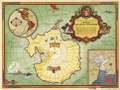
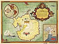 Authorized map of the Second Byrd Antarctic Expedition. LOC 98687113.jpg 7,168 × 5,376; 7.55 MB
-
 Authorized map of the Second Byrd Antarctic Expedition. LOC 98687113.tif 7,168 × 5,376; 110.25 MB
-
 Bell telephone magazine (1922) (14753237731).jpg 980 × 2,018; 200 KB
-
 Bell telephone magazine (1922) (14754064754).jpg 2,318 × 1,464; 879 KB
-
 Bell telephone magazine (1922) (14776278053).jpg 2,522 × 1,026; 401 KB
-
 Canton Harbour Map 1934.jpg 3,431 × 3,503; 3.74 MB
-

-
 Chickamauga and Chattanooga National Military Park, Ga. (Chickamauga Battlefield). LOC 99447319.jpg 10,250 × 10,245; 16.27 MB
-
 Chickamauga and Chattanooga National Military Park, Ga. (Chickamauga Battlefield). LOC 99447319.tif 10,250 × 10,245; 300.44 MB
-
 Emek Zeboulon (FL42836911 3502581).jpg 4,733 × 7,225; 47.49 MB
-
 Emek Zeboulon zone d'habitation (FL42837092 3502582).jpg 4,379 × 7,088; 43.12 MB
-
 Entente Balkanique.png 969 × 513; 9 KB
-
 Eretz Israel (FL168744109 2716049).jpg 11,256 × 15,818; 218.4 MB
-
 French Service géographique de l'armée, Homs (FL147448669 4083900).jpg 12,999 × 18,851; 256.82 MB
-
 French Service géographique de l'armée, Tell Kalakh (FL147439284 4083740).jpg 13,012 × 17,392; 271.8 MB
-
 French Service géographique de l'armée, Tell Rifat (FL147439316 4083833).jpg 13,138 × 17,838; 256.99 MB
-
 Harta București cu Împrejurimile 1934 Socec.jpg 2,022 × 2,686; 4.9 MB
-
 Hugo Herrmann, Generalkarte von Palaestina (FL25553441 2367020).jpg 12,135 × 25,954; 413.26 MB
-

-
 London map - Bacon - 1934.jpg 1,920 × 1,522; 572 KB
-
 Map-edyc1.jpg 1,603 × 1,201; 436 KB
-
 Mapa da Rede do Vouga 3 - GazetaCF 1105 1934.jpg 550 × 542; 226 KB
-
 Planskizze Fietz.jpg 518 × 508; 48 KB
-
 Preliminary base map, Great Smoky Mountains National Park. LOC 99446157.jpg 17,131 × 8,075; 24.42 MB
-
 Preliminary base map, Great Smoky Mountains National Park. LOC 99446157.tif 17,131 × 8,075; 395.77 MB
-
 Reconnaissance erosion survey of the State of North Carolina. LOC 99446155.jpg 16,008 × 8,384; 22.27 MB
-
 Reconnaissance erosion survey of the State of North Carolina. LOC 99446155.tif 16,008 × 8,384; 383.98 MB
-
 Reconnaissance erosion survey of the State of Tennessee. LOC 99446156.jpg 10,148 × 11,050; 15.39 MB
-
 Reconnaissance erosion survey of the State of Tennessee. LOC 99446156.tif 10,148 × 11,050; 320.82 MB
-
 Shenandoah National Park. LOC 93681946.jpg 6,625 × 4,352; 2.7 MB
-
 Shenandoah National Park. LOC 93681946.tif 6,625 × 4,352; 82.49 MB
-
 Shiloh National Military Park, Tenn. LOC 99448460.jpg 6,386 × 8,908; 7.59 MB
-
 Shiloh National Military Park, Tenn. LOC 99448460.tif 6,386 × 8,908; 162.75 MB
-
 Sketch map Samoa in the Pacific.jpg 843 × 648; 104 KB
-
 Slănic Moldova map.jpg 4,169 × 2,617; 8.26 MB
-

-

-
 Survey of Palestine, Al Haram (FL62919418 3525991).jpg 12,964 × 10,678; 140.1 MB
-

-
 Survey of Palestine, Aqir including Kefar Bilu (FL61174830 3523187).jpg 14,558 × 10,292; 154.94 MB
-
 Survey of Palestine, Beit Safafa (FL168744116 3526104).jpg 17,063 × 13,984; 199.33 MB
-
 Survey of Palestine, Deir Suneid (FL190848367 1082102).jpg 10,184 × 9,255; 90.47 MB
-
 Survey of Palestine, Fajja (FL62919439 3523562).jpg 9,742 × 13,674; 137.08 MB
-

-
 Survey of Palestine, Jalil Ash Shamaliya, Jalil al Qibliya (FL60915881 3522676).jpg 19,026 × 11,286; 194.55 MB
-
 Survey of Palestine, Kefar Gamim Gat Rimmon Al Yahudiya (FL62919444 3525884).jpg 12,066 × 15,868; 195.92 MB
-
 Survey of Palestine, Kefar Sava, Magdiel - block plan index (FL27964821 2630746).jpg 12,753 × 9,486; 150.47 MB
-
 Survey of Palestine, Nu'eima (FL63660413 3520407).jpg 5,520 × 3,736; 16.1 MB
-
 Survey of Palestine, Palestine (FL27965357 2652236).jpg 5,668 × 13,175; 86.46 MB
-
 Survey of Palestine, Palestine (FL32698029 2367906).jpg 14,422 × 24,146; 521.75 MB
-
 Survey of Palestine, Palestine (FL33248458 2366889).jpg 14,283 × 24,086; 482.13 MB
-
 Survey of Palestine, Palestine (FL33250717 3766691).jpg 14,525 × 24,115; 428.27 MB
-
 Survey of Palestine, Petah Tiqva, Ein Ganim, Al Mirr, Mahne Yehuda (FL60915895 3520667).jpg 16,764 × 14,432; 225.57 MB
-
 Survey of Palestine, Qalqilya (FL190848388 1082102).jpg 12,623 × 9,551; 120.05 MB
-
 Survey of Palestine, Yibna (FL197995718 3523190).jpg 13,191 × 18,093; 213.29 MB
-
 Survey of Palestine, Yibna - block plan index (FL27964894 2630745).jpg 13,236 × 17,662; 251.7 MB
-
 Survey of Palestine, אל קביבה, בית חנן, כוללת כפר אהרן (FL190848381 1082102).jpg 12,876 × 10,800; 134.68 MB
-
 Survey of Palestine, יריחו (FL33135605 3520281).jpg 14,887 × 17,477; 322.58 MB
-
 Survey of Palestine, מפת דרכים בפלשתינה (אי) לנסיעות באוטומוביל 01 (FL57568498 2601370).jpg 9,420 × 14,118; 202.16 MB
-
 Survey of Palestine, מפת דרכים בפלשתינה (אי) לנסיעות באוטומוביל 02 (FL57568500 2601370).jpg 9,420 × 14,118; 198.26 MB
-
 The Alaska Line. LOC 99466709.jpg 8,667 × 6,486; 8.85 MB
-
 The Alaska Line. LOC 99466709.tif 8,667 × 6,486; 160.83 MB
-

-
 Topographic map, Great Smoky Mountains National Park, Tennessee and North Carolina. LOC 99446150.tif 9,296 × 8,338; 221.76 MB
-
 Zakopane WIG 1-100000 (1934).jpg 4,722 × 3,994; 5.54 MB
-

-
 Zionist Federation of Great Britain and Ireland, Palestine 02-text (FL8693622 2367825).jpg 5,460 × 2,685; 21.87 MB
-
 Zui xin Beiping quan shi xiang tu. LOC 2006458555.jpg 6,355 × 9,102; 10.64 MB
-
 Zui xin Beiping quan shi xiang tu. LOC 2006458555.tif 6,355 × 9,102; 165.49 MB
-
 ארץ ישראל (FL33134524 2642746).jpg 11,219 × 15,944; 293.69 MB
-
 ארץ ישראל Erez Israel (FL197701839 1100165).jpg 11,122 × 15,834; 242.21 MB
-
 ארץ ישראל Erez Israel (FL197701853 1108519).jpg 11,906 × 16,711; 289.79 MB
-
 خريطة فلسطين للسيارات (FL7330881 2515021).jpg 5,728 × 9,076; 82.03 MB
-
 خريطة فلسطين للسيارات (FL7330882 2515021).jpg 5,879 × 9,056; 85.24 MB


_(14753237731).jpg)
_(14754064754).jpg)


._LOC_99447319.jpg)
.jpg)
.jpg)

.jpg)
.jpg)
.jpg)
.jpg)

.jpg)
,_Carte_de_navigation_a%C3%A9rienne._Luchtvaarkaart_02_(FL62896796_2551559).jpg)


.jpg)
.jpg)
.jpg)
.jpg)
.jpg)
.jpg)
_-_block_plan_index_(FL27964846_2630749).jpg)
.jpg)
.jpg)
.jpg)
.jpg)
.jpg)
.jpg)
.jpg)
.jpg)
.jpg)
.jpg)
.jpg)
.jpg)
.jpg)
.jpg)
_%D7%9C%D7%A0%D7%A1%D7%99%D7%A2%D7%95%D7%AA_%D7%91%D7%90%D7%95%D7%98%D7%95%D7%9E%D7%95%D7%91%D7%99%D7%9C_01_(FL57568498_2601370).jpg)
_%D7%9C%D7%A0%D7%A1%D7%99%D7%A2%D7%95%D7%AA_%D7%91%D7%90%D7%95%D7%98%D7%95%D7%9E%D7%95%D7%91%D7%99%D7%9C_02_(FL57568500_2601370).jpg)


.jpg)
.jpg)
.jpg)

.jpg)
.jpg)
.jpg)
.jpg)
.jpg)
_(14776278053).jpg)