Category:1967 maps of the United Kingdom
Jump to navigation
Jump to search
Media in category "1967 maps of the United Kingdom"
The following 11 files are in this category, out of 11 total.
-
 1967 data of the British Isles - part 1.jpg 4,292 × 2,872; 3.01 MB
-
 1967 data of the British Isles - part 2.jpg 3,948 × 2,873; 1.23 MB
-
 Central and Northern England, 1967.jpg 2,130 × 2,888; 1.43 MB
-
 England, Wales and Ireland, 1967.jpg 4,766 × 2,884; 3.23 MB
-
 Great Britain and Ireland, 1967.jpg 2,884 × 4,096; 2.39 MB
-
 London and Central Scotland, 1967.jpg 1,817 × 1,817; 1.8 MB
-
 Ministry of Defence Series 1404 sheet 171-C Birmingham, published 1967.jpg 6,936 × 5,430; 10.81 MB
-
 Ordnance Survey Quarter-inch sheet 4 Western Highlands, published 1967.jpg 9,627 × 8,869; 8.85 MB
-
 Ordnance Survey Quarter-inch sheet 5 Eastern Highlands, published 1967.jpg 9,635 × 8,911; 10.25 MB
-
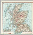 Scotland, 1967.jpg 2,711 × 2,873; 3.03 MB
-
 Windsor street gasworks 1967.png 486 × 404; 488 KB


