Category:19 - 25 Prince Alfred Road
Jump to navigation
Jump to search
| Object location | | View all coordinates using: OpenStreetMap |
|---|
This is a category about listed building number 1072962. |
building in Liverpool, Merseyside, UK  | |||||
| Upload media | |||||
| Instance of | |||||
|---|---|---|---|---|---|
| Location | Liverpool, Merseyside, North West England, England | ||||
| Street address |
| ||||
| Heritage designation |
| ||||
 | |||||
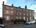
Group of four early 19th century houses, Grade II listed.
Media in category "19 - 25 Prince Alfred Road"
The following 2 files are in this category, out of 2 total.
-
 19 - 25 Prince Alfred Road 1.jpg 4,533 × 3,587; 8.14 MB
-
 19 - 25 Prince Alfred Road 2.jpg 3,913 × 3,387; 6.96 MB
