Category:19th-century maps of Igersheim
Jump to navigation
Jump to search
Media in category "19th-century maps of Igersheim"
The following 4 files are in this category, out of 4 total.
-
-
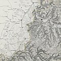
 Topographischer Atlas des Koenigreichs Württemberg - Blatt 2 Mergentheim.jpg 2,662 × 2,660; 4.74 MB
-
 Topographischer Atlas des Koenigreichs Württemberg - Blatt 3 Niederstetten.jpg 2,662 × 2,660; 4.76 MB
-
 1881 Igersheim - Bebauung.jpg 300 × 300; 77 KB
,_Ahorn_(Baden),_Assamstadt).jpg)


