Category:19th-century maps of the Indian Ocean
Jump to navigation
Jump to search
Subcategories
This category has the following 3 subcategories, out of 3 total.
Media in category "19th-century maps of the Indian Ocean"
The following 61 files are in this category, out of 61 total.
-

-

-

-
 Image taken from page 409 of 'A. Rochon's .(11000252223).jpg 2,320 × 3,256; 1.54 MB
-

-
-

-
 Südwest-Asien Besitzungen Europäischer Mächte 1866.tif 6,404 × 5,156; 94.49 MB
-

-

-

-

-

-

-

-

-

-
-

-

-

-

-

-

-

-

-

-

-

-

-

-

-

-

-
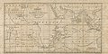
 IMRAY(1893) p124 PRINCE EDWARD ISLANDS.jpg 2,794 × 3,116; 3.19 MB
-
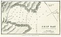 IMRAY(1893) p124 SHIP BAY, POSSESSION ISLAND.jpg 2,816 × 1,718; 2.16 MB
-
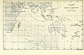
 IMRAY(1893) p130 CROZET ISLANDS.jpg 4,644 × 2,976; 4.56 MB
-

-
-
-
 195 of 'The “Beaumont” Geography and Map Tracing Book' (11246781476).jpg 2,416 × 1,832; 901 KB
-

-

-

-

-

-

-

-

-
 Admiralty Chart No 748a Indian Ocean southern portion, Published 1875.jpg 22,190 × 11,347; 50.57 MB
-
 Admiralty Chart No 748b Indian Ocean northern portion, Published 1870.jpg 22,325 × 11,511; 101.38 MB
-

-

-
-

-

-
 Die Gartenlaube (1885) b 635 2.jpg 712 × 794; 170 KB
-
 Humboldt; Monatsschrift für die gesamten Naturwissenschaften (1882) (14593431028).jpg 2,576 × 1,770; 608 KB
-
 Indian Ocean - Northern Portion RMG F3571.jpg 1,280 × 657; 225 KB
-
 Meyer‘s Zeitungsatlas 099 – Physikalische Karte vom Indischen Meere.jpg 7,434 × 6,224; 14.81 MB
-
 Wallace Island Life p425.png 1,360 × 1,201; 41 KB
.jpg)
%27_(11160382873).jpg)
%27_(11170085044).jpg)
.jpg)
.jpg)
%27_(11004650483).jpg)
.jpg)
.jpg)
.jpg)
.jpg)
_(14776165852).jpg)
.jpg)
_oszt%C3%A1ly_sz%C3%A1mara_..._t%C3%A9rk%C3%A9ppel%27_(11202900453).jpg)
%27_(11208291043).jpg)
.jpg)
%27_(11209008446).jpg)
.jpg)
%27_(11208310184).jpg)
.jpg)
.jpg)
%27_(11213256304).jpg)
.jpg)
%27_(11213102874).jpg)
.jpg)
%27_(11212859913).jpg)
%27_(11210696453).jpg)
%27_(11212126614).jpg)
.jpg)
.jpg)
%27_(11213777645).jpg)
.jpg)
.jpg)
_p124_PRINCE_EDWARD_ISLANDS.jpg)
_p124_SHIP_BAY,_POSSESSION_ISLAND.jpg)
_p130_CROZET_ISLANDS.jpg)
.jpg)
%27_(11246030014).jpg)
%27_(11246485795).jpg)
.jpg)
%27_(11161992333).jpg)
.jpg)
.jpg)
%27_(11100530516).jpg)
.jpg)
.jpg)


.jpg)
.jpg)

_b_635_2.jpg)
_(14593431028).jpg)


.jpg)