Category:1 - 9 St Aidan's Terrace, Claughton
Jump to navigation
Jump to search
| Object location | | View all coordinates using: OpenStreetMap |
|---|
This is a category about listed building number 1201769. |
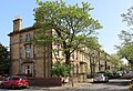
Grade II listed terrace of houses in Claughton, Wirral, Merseyside, UK  | |||||
| Upload media | |||||
| Instance of | |||||
|---|---|---|---|---|---|
| Location | Claughton, Birkenhead, Wirral, Merseyside, North West England, England | ||||
| Heritage designation |
| ||||
 | |||||
Terrace of three-storeyed houses, c1850. Ashlar-faced over brick with Welsh slate roof. The railings to the frontages are included in the listing.
Media in category "1 - 9 St Aidan's Terrace, Claughton"
The following 4 files are in this category, out of 4 total.
-
 1 - 9 St Aidan's Terrace & 44 Forest Road.jpg 4,344 × 3,369; 11.32 MB
-
 1 - 9 St Aidan's Terrace railings.jpg 4,941 × 3,189; 11.76 MB
-
 1 - 9 St Aidan's Terrace.jpg 4,764 × 3,237; 13.03 MB
-
 St Aidan's Terrace, Birkenhead.JPG 4,000 × 3,000; 2.99 MB


