Category:2000 U.S. presidential election maps
Jump to navigation
Jump to search
Subcategories
This category has the following 4 subcategories, out of 4 total.
Media in category "2000 U.S. presidential election maps"
The following 20 files are in this category, out of 20 total.
-
 2000 Democratic presidential primaries.png 1,920 × 1,187; 230 KB
-
 2000 Presidential Election, Results by Congressional District.png 1,500 × 960; 85 KB
-
 2000 Republican Primary Results.png 525 × 325; 40 KB
-
 2000 Republican Primary Results.svg 990 × 627; 327 KB
-
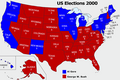
 2000 US elections map.png 800 × 495; 31 KB
-
 2000-elex-map (30254981334).jpg 1,545 × 1,103; 530 KB
-
 2000GOPprimaries fixed.png 640 × 469; 69 KB
-
 2000GOPprimaries.png 640 × 469; 70 KB
-
 2000ReformMailInBallotResults.svg 959 × 593; 32 KB
-
 Cartogram 2008 red blue.png 628 × 287; 8 KB
-
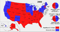
 ElectoralCollege2000-Large-BushRed-GoreBlue.png 3,697 × 2,472; 670 KB
-
 ElectoralCollege2000-Large.png 1,182 × 635; 175 KB
-
 ElectoralCollege2000.svg 1,020 × 593; 28 KB
-
 ElectoralCollege2000withPieCharts.svg 1,220 × 593; 112 KB
-
 Map of USA presidential elections 2000.PNG 280 × 183; 13 KB
-
 Mapa elecciones EEUU.jpg 763 × 422; 46 KB
-
 MN President 2000.svg 810 × 810; 5.68 MB
-
 US Presidential Election Results in Nebraska by County, 2000.png 282 × 133; 17 KB
-
 Rhode Island Presidential Election Municipality Results 2000.svg 810 × 810; 49 KB
-
 US presidential election 2000 map.svg 959 × 593; 343 KB


.jpg)


