Category:2014 in South Yorkshire
Jump to navigation
Jump to search
Ceremonial counties of England: Bedfordshire · Berkshire · Buckinghamshire · Cambridgeshire · Cheshire · Cornwall · Cumbria · Derbyshire · Devon · Dorset · Durham · East Riding of Yorkshire · East Sussex · Essex · Gloucestershire · Greater London · Greater Manchester · Hampshire · Herefordshire · Hertfordshire · Isle of Wight · Kent · Lancashire · Leicestershire · Lincolnshire · Merseyside · Norfolk · North Yorkshire · Northamptonshire · Northumberland · Nottinghamshire · Oxfordshire · Rutland · Shropshire · Somerset · South Yorkshire · Staffordshire · Suffolk · Surrey · Tyne and Wear · Warwickshire · West Midlands · West Sussex · West Yorkshire · Wiltshire · Worcestershire
City-counties: Bristol · City of London
Former historic counties:
Other former counties:
City-counties: Bristol · City of London
Former historic counties:
Other former counties:
Subcategories
This category has the following 14 subcategories, out of 14 total.
Media in category "2014 in South Yorkshire"
The following 53 files are in this category, out of 53 total.
-

-

-

-

-
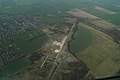
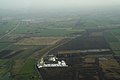
 Blaxton Common, aerial 2014 - geograph.org.uk - 3879379.jpg 1,024 × 683; 80 KB
-
 Blaxton, aerial 2014 - geograph.org.uk - 3879383.jpg 1,024 × 683; 128 KB
-
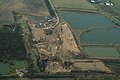
 Disused Thorne Colliery, aerial 2014 - geograph.org.uk - 3878933.jpg 640 × 427; 59 KB
-
 Disused Thorne Colliery, aerial 2014 - geograph.org.uk - 3878939.jpg 640 × 427; 52 KB
-
 Disused Thorne Colliery, aerial 2014 - geograph.org.uk - 3878951.jpg 1,024 × 683; 117 KB
-

-

-

-

-
 Doncaster Railport, aerial 2014 - geograph.org.uk - 4163186.jpg 640 × 427; 86 KB
-
-
 Doncaster Station and Prison, aerial 2014 - geograph.org.uk - 4163188.jpg 1,024 × 683; 183 KB
-
 Doncaster's Plantation, aerial 2017 - geograph.org.uk - 5330159.jpg 474 × 640; 58 KB
-

-

-
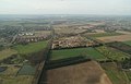
 Finningley area, aerial 2014 - geograph.org.uk - 3879706.jpg 640 × 427; 52 KB
-
 Finningley Quarry, aerial 2014 - geograph.org.uk - 3879769.jpg 640 × 427; 42 KB
-

-
 Gate Farm and Great Gate Wood, aerial 2014 - geograph.org.uk - 3879361.jpg 1,024 × 683; 115 KB
-
-
 Hatfield Colliery, aerial 2014 - geograph.org.uk - 3876649.jpg 640 × 427; 52 KB
-
 Hatfield Moors, aerial 2014 - geograph.org.uk - 3876608.jpg 640 × 399; 45 KB
-
 Hatfield Moors, aerial 2014 - geograph.org.uk - 3876641.jpg 640 × 410; 36 KB
-
 Hatfield Moors, aerial 2014 - geograph.org.uk - 3879303.jpg 640 × 427; 64 KB
-
 Huggin Carr, aerial 2014 - geograph.org.uk - 3879324.jpg 1,024 × 683; 74 KB
-

-
 Mexborough from the air - geograph.org.uk - 3950103.jpg 640 × 480; 128 KB
-
 Moorends, aerial 2014 - geograph.org.uk - 3876602.jpg 1,024 × 683; 179 KB
-
 New road bridge, Joan Croft, aerial 2014 - geograph.org.uk - 4100392.jpg 1,024 × 683; 142 KB
-
-
 Peat Works on Hatfield Moor, aerial 2014 - geograph.org.uk - 3879218.jpg 1,024 × 683; 94 KB
-
 Pennine industry - geograph.org.uk - 4201111.jpg 4,603 × 1,836; 1.87 MB
-
-

-

-

-

-
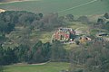 Rossington Hall, aerial 2014 - geograph.org.uk - 3879815.jpg 640 × 427; 58 KB
-

-
-

-

-
 South Elmsall from the air - geograph.org.uk - 4035636.jpg 640 × 480; 103 KB
-
 Sports Quarry, aerial 2014 - geograph.org.uk - 3879744.jpg 1,024 × 624; 105 KB
-
 Thorne and edge of Nun's Moor, aerial 2014 - geograph.org.uk - 3876564.jpg 768 × 1,024; 166 KB
-
 Thorne, looking westwards, aerial 2014 - geograph.org.uk - 3876563.jpg 683 × 1,024; 160 KB
-

-
 Tickhill GP 2014 (15032211092).jpg 1,620 × 1,080; 372 KB
-
 Tween Bridge Windfarm, aerial 2014 - geograph.org.uk - 3876567.jpg 640 × 427; 34 KB


_-_geograph.org.uk_-_3879392.jpg)


_Airport,_aerial_2014_-_geograph.org.uk_-_3879666.jpg)
_Airport,_aerial_2014_-_geograph.org.uk_-_3879675.jpg)

.jpg)


_-_geograph.org.uk_-_4163030.jpg)


.jpg)
