Category:20th-century maps of Papua New Guinea
Jump to navigation
Jump to search
Countries of Oceania: Australia · Fiji · Kiribati · New Zealand · Papua New Guinea · Samoa · Solomon Islands · Tonga · Tuvalu · Vanuatu
Other areas: Hawaii – Partly: Indonesia
Other areas: Hawaii – Partly: Indonesia
Subcategories
This category has the following 4 subcategories, out of 4 total.
1
N
- 20th-century maps of New Guinea (18 F)
Media in category "20th-century maps of Papua New Guinea"
The following 13 files are in this category, out of 13 total.
-
 Hansemann Coast and Schouten Islands - Papua New Guinea.jpg 4,032 × 3,024; 3.8 MB
-
 Karte von Neu-Lauenburg.jpg 4,032 × 3,024; 2.01 MB
-
 Kartenausschnitt Astrolabe Bai und Umgebung.jpg 4,032 × 3,024; 5.46 MB
-
 Kartenausschnitt Brecher Bucht - Neuguinea.jpg 4,032 × 3,024; 2.5 MB
-
 Kartenausschnitt Elisabeth-Bucht Neuirland Kolonialatlas.jpg 4,032 × 3,024; 2.39 MB
-
 Kartenausschnitt Papua Neuguinea Nordküste.jpg 4,032 × 3,024; 2.56 MB
-
 Krater Halbinsel, Neubritannien.jpg 3,024 × 4,032; 3.57 MB
-
 Muller Range Kartenausschnitt aus dem Grossen Deutschen Kolonialatlas.jpg 4,032 × 3,024; 3.74 MB
-
 Neuguinea Huon Golf.jpg 4,032 × 3,024; 4.62 MB
-
 Westküste Papua Neuguineas - Kolonialatlas1910.jpg 4,032 × 3,024; 2.6 MB
-
 Wirbelwind Riff Papua Neuguinea.jpg 4,032 × 3,024; 3.35 MB
-
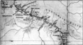 Karte Sepik Expedition 1912-13.png 2,436 × 1,324; 2.23 MB
-
 East Indies - btv1b53209798t (2 of 2).jpg 12,039 × 9,130; 16.68 MB


.jpg)