Category:2e Dorpsstraat 54, Zeist
Jump to navigation
Jump to search
| Object location | | View all coordinates using: OpenStreetMap |
|---|
|
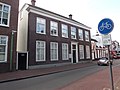
This is a category about rijksmonument number 40370
|
| Address |
|
building in Zeist, Netherlands  | |||||
| Upload media | |||||
| Instance of | |||||
|---|---|---|---|---|---|
| Location | Zeist, Utrecht, Netherlands | ||||
| Street address |
| ||||
| Located on street |
| ||||
| Heritage designation |
| ||||
 | |||||
Media in category "2e Dorpsstraat 54, Zeist"
The following 3 files are in this category, out of 3 total.
-
 Dorpsstraat 54, voorgevel - Zeist - 20221650 - RCE.jpg 827 × 1,200; 188 KB
-
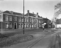 Dorpsstraat bij Beek en Royen, vanuit het noorden - Zeist - 20221641 - RCE.jpg 1,200 × 953; 211 KB
-
 RM40370 2e Dorpsstraat 54.JPG 4,320 × 3,240; 1.84 MB

