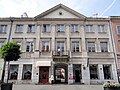
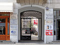
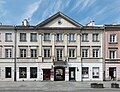
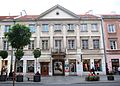
Category:39, Nowy Świat Street
Jump to navigation
Jump to search
| Object location | | View all coordinates using: OpenStreetMap |
|---|
 | |||||
| Upload media | |||||
| Instance of | |||||
|---|---|---|---|---|---|
| Location | Śródmieście, Warsaw, Masovian Voivodeship, Poland | ||||
| Street address |
| ||||
| Heritage designation |
| ||||
| Inception |
| ||||
 | |||||
Media in category "39, Nowy Świat Street"
The following 8 files are in this category, out of 8 total.
-
 39, Nowy Świat Street - 01.jpg 3,648 × 2,736; 1.84 MB
-
 39, Nowy Świat Street - 02.jpg 3,648 × 2,736; 1.76 MB
-
 Kamienica przy ul. Nowy Świat 39 w Warszawie 2020.jpg 5,980 × 4,580; 13.3 MB
-
 Milk Bar on Nowy Świat st. (3526889324).jpg 2,848 × 4,288; 5.79 MB
-
 Now15DSC 1099.jpg 2,630 × 1,888; 1.78 MB
-
 Varsovia (Polonia) Warszawa (Polska). 63.jpg 3,500 × 2,192; 2.35 MB
-
 Warszawa, ul. Nowy Świat 37, 39 20170516 001.jpg 5,996 × 4,003; 11.68 MB
-
 Warszawa, ul. Nowy Świat 39 20170516 001.jpg 5,996 × 4,003; 10.77 MB


.jpg)

_Warszawa_(Polska)._63.jpg)

