Category:A143 road (England)
Jump to navigation
Jump to search

road in England  | |||||
| Upload media | |||||
| Instance of | |||||
|---|---|---|---|---|---|
| Location |
| ||||
| Transport network |
| ||||
| Length |
| ||||
 | |||||
Subcategories
This category has the following 3 subcategories, out of 3 total.
Media in category "A143 road (England)"
The following 82 files are in this category, out of 82 total.
-
 'The Fox' public house, on the A143 - geograph.org.uk - 313120.jpg 640 × 480; 58 KB
-
 'The Old Kings Head' inn - geograph.org.uk - 358551.jpg 640 × 455; 54 KB
-
 -2021-05-07 St¬ Olave's Bridge, River Waveney, Norfolk.jpg 3,456 × 2,592; 3.6 MB
-
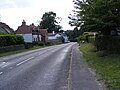
 -2021-07-12 A143 road, Ellingham, Norfolk.jpg 3,456 × 2,592; 3.95 MB
-
 -2021-07-12 A143 road, Kirby Row, Ellingham, Norfolk.jpg 3,456 × 2,592; 3.89 MB
-
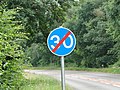 -2021-07-12 Minimum speed limit, A143 road, Kirby Row, Ellingham, Norfolk.jpg 3,456 × 2,592; 3.9 MB
-
 -2021-07-12 Road sign, A143 road, Ellingham, Norfolk.jpg 3,456 × 2,592; 3.95 MB
-
 -2021-07-12 Seagull and road kill, Broome, Norfolk.jpg 3,456 × 2,592; 3.96 MB
-
 A Lay-by along the A143 - geograph.org.uk - 358365.jpg 640 × 442; 53 KB
-
 A143 - geograph.org.uk - 1240159.jpg 640 × 480; 85 KB
-
 A143 Beccles Road, Fritton - geograph.org.uk - 1439573.jpg 640 × 480; 87 KB
-
 A143 Beccles Road, Fritton - geograph.org.uk - 1439575.jpg 3,072 × 2,304; 1.39 MB
-
 A143 Beccles Road, Fritton - geograph.org.uk - 1439582.jpg 3,072 × 2,304; 1.38 MB
-
 A143 Beccles Road, Haddiscoe - geograph.org.uk - 1439503.jpg 3,072 × 2,304; 1.44 MB
-
 A143 Beccles Road, Haddiscoe - geograph.org.uk - 1439506.jpg 3,072 × 2,304; 1.44 MB
-
 A143 Beccles Road, Haddiscoe - geograph.org.uk - 1439649.jpg 3,072 × 2,304; 1.48 MB
-
 A143 Bury Road, Wickham Street - geograph.org.uk - 4193079.jpg 3,072 × 2,304; 1.8 MB
-
 A143 bypasses Earsham - geograph.org.uk - 442222.jpg 640 × 480; 65 KB
-
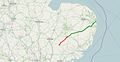 A143 road map.jpg 1,581 × 821; 113 KB
-
 A143, Fritton - geograph.org.uk - 773518.jpg 640 × 486; 98 KB
-
 Ashdown Cottage, Horringer - geograph.org.uk - 1394142.jpg 640 × 427; 113 KB
-

-

-
 Big Al's caff off the A143 - geograph.org.uk - 190441.jpg 640 × 427; 80 KB
-
 Botesdale - geograph.org.uk - 2183804.jpg 1,024 × 722; 274 KB
-
 Bungay Railway station.jpg 640 × 480; 142 KB
-
 Bungay Village Sign - geograph.org.uk - 223031.jpg 480 × 640; 98 KB
-

-
 County boundary sign, Bungay - geograph.org.uk - 1334402.jpg 640 × 480; 398 KB
-
 County Boundary, Bungay - geograph.org.uk - 1334355.jpg 640 × 480; 365 KB
-

-
 Empty Shell - geograph.org.uk - 975382.jpg 640 × 480; 60 KB
-
 Homersfield Railway Station Site.jpg 640 × 480; 58 KB
-
 House by the A143 (Beccles Road) - geograph.org.uk - 1537956.jpg 640 × 463; 58 KB
-
 House on the A143 - geograph.org.uk - 313116.jpg 640 × 480; 56 KB
-
 Isolated house on A143 - geograph.org.uk - 3407002.jpg 4,320 × 3,240; 4.3 MB
-

-
 K6 telephone box in Beccles Road (A143) - geograph.org.uk - 1578348.jpg 480 × 640; 129 KB
-
 Path along the New Cut - geograph.org.uk - 1719371.jpg 640 × 475; 116 KB
-
 Please Drive Carefully - geograph.org.uk - 1240174.jpg 480 × 640; 108 KB
-
 Removed dual carriageway - geograph.org.uk - 992485.jpg 640 × 480; 77 KB
-
 Road bridge - geograph.org.uk - 678756.jpg 640 × 480; 63 KB
-
 Road junction - geograph.org.uk - 1019045.jpg 640 × 480; 92 KB
-
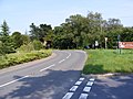
 Road junction on the A143 - geograph.org.uk - 1427332.jpg 640 × 408; 56 KB
-
 Road sign - geograph.org.uk - 610808.jpg 480 × 640; 89 KB
-
 Roadsigns on the A143 Beccles Road - geograph.org.uk - 1439646.jpg 3,072 × 2,304; 1.67 MB
-
 Sign at sharp bend in Station Road - geograph.org.uk - 1483403.jpg 640 × 480; 64 KB
-
 Spring Cottages along the A143 - geograph.org.uk - 312879.jpg 640 × 480; 60 KB
-
 St Olaves Bridge - geograph.org.uk - 664800.jpg 480 × 640; 109 KB
-
 St.Olaves - geograph.org.uk - 678521.jpg 640 × 480; 69 KB
-

-

-
 The A143 - geograph.org.uk - 1578611.jpg 480 × 640; 102 KB
-
 The A143 at Redenhall - geograph.org.uk - 40672.jpg 640 × 427; 97 KB
-
 The A143 at Sturmer, Essex - geograph.org.uk - 308664.jpg 640 × 416; 68 KB
-
 The A143 Beccles Road Bridge - geograph.org.uk - 1439486.jpg 3,072 × 2,304; 1.39 MB
-
 The A143 Bypass - geograph.org.uk - 1597060.jpg 640 × 480; 72 KB
-
 The A143 Bypass - geograph.org.uk - 1597130.jpg 640 × 480; 55 KB
-
 The A143 Bypass - geograph.org.uk - 1597132.jpg 640 × 480; 68 KB
-
 The A143 Bypass - geograph.org.uk - 1597134.jpg 640 × 480; 86 KB
-
 The A143 Bypass - geograph.org.uk - 1597136.jpg 640 × 480; 59 KB
-
 The A143 Heading Towards Wattisfield - geograph.org.uk - 975388.jpg 640 × 480; 69 KB
-
 The Bell Inn - geograph.org.uk - 664775.jpg 640 × 480; 164 KB
-
 The Bell Inn - geograph.org.uk - 664780.jpg 640 × 480; 191 KB
-
 The Bell Inn - sign - geograph.org.uk - 664792.jpg 480 × 640; 141 KB
-
 The Bell Inn, St Olaves - geograph.org.uk - 126750.jpg 640 × 480; 70 KB
-
 The Crown Inn in Beccles Road (A143) - geograph.org.uk - 1578356.jpg 640 × 465; 102 KB
-
 The Decoy Tavern, Fritton - geograph.org.uk - 773446.jpg 640 × 451; 71 KB
-

-
 The old road - geograph.org.uk - 397421.jpg 640 × 477; 96 KB
-
 The Rose ^ Crown Public House, Stanton - geograph.org.uk - 5088140.jpg 3,072 × 2,304; 1.83 MB
-

-
 UK road A143.PNG 568 × 184; 6 KB
-
 Viaduct over the A143 - geograph.org.uk - 312892.jpg 640 × 410; 68 KB
-
 View east along the A143 road - geograph.org.uk - 1767777.jpg 640 × 480; 110 KB
-

-
 View north-west along Station Road - geograph.org.uk - 1483399.jpg 640 × 480; 114 KB
-

-
-
 Whitehouse Farm Cottages - geograph.org.uk - 116648.jpg 640 × 480; 72 KB
-
 Wickham Street, Bury Road - geograph.org.uk - 3854538.jpg 640 × 480; 117 KB
-


_past_Cherry_Lane_Garden_Centre_-_geograph.org.uk_-_1537951.jpg)
_through_Haddiscoe_-_geograph.org.uk_-_1578359.jpg)


_-_geograph.org.uk_-_1537937.jpg)


_-_geograph.org.uk_-_1578361.jpg)

_-_geograph.org.uk_-_1537956.jpg)


_-_geograph.org.uk_-_1578348.jpg)


_-_geograph.org.uk_-_1537936.jpg)


_-_geograph.org.uk_-_1578356.jpg)

_-_geograph.org.uk_-_1537935.jpg)


_junction_-_geograph.org.uk_-_1578363.jpg)


_-_geograph.org.uk_-_1537952.jpg)

_-_geograph.org.uk_-_1537966.jpg)


