Category:A7 road (Great Britain)
Jump to navigation
Jump to search
road in north-west England and southern Scotland    | |||||
| Upload media | |||||
| Instance of | |||||
|---|---|---|---|---|---|
| Location | |||||
| Transport network |
| ||||
| Connects with | |||||
| Has part(s) |
| ||||
| Length |
| ||||
| Different from | |||||
 | |||||
Subcategories
This category has the following 7 subcategories, out of 7 total.
D
- Dalkeith Road, Edinburgh (25 F)
E
- Eden Bridge (A7) (9 F)
H
- Highmill Bridge (3 F)
M
- Middleton Mains (2 F)
N
- Newbattle Viaduct (10 F)
S
- Skipper's Bridge (8 F)
- South Clerk Street (9 F)
Media in category "A7 road (Great Britain)"
The following 80 files are in this category, out of 80 total.
-
 A mobile sign by the A7 - geograph.org.uk - 705199.jpg 640 × 480; 126 KB
-
 A7 - A720 Roundabout Sign.jpg 496 × 509; 36 KB
-
 A7 - geograph.org.uk - 319547.jpg 640 × 480; 216 KB
-
 A7 - geograph.org.uk - 607338.jpg 480 × 640; 103 KB
-
 A7 - geograph.org.uk - 750890.jpg 640 × 480; 64 KB
-
 A7 approaching a sharp bend - geograph.org.uk - 600968.jpg 640 × 480; 86 KB
-
 A7 at Newtongrange - geograph.org.uk - 1639740.jpg 640 × 479; 93 KB
-
 A7 below Stibbiegill Knowe - geograph.org.uk - 1250700.jpg 640 × 480; 60 KB
-
 A7 Canonbie Bypass - geograph.org.uk - 334890.jpg 640 × 480; 102 KB
-
 A7 Canonbie Bypass - geograph.org.uk - 334894.jpg 640 × 480; 80 KB
-
 A7 Historic Borders Road. - geograph.org.uk - 791970.jpg 640 × 480; 74 KB
-
 A7 Middleton Moor - geograph.org.uk - 547018.jpg 640 × 480; 77 KB
-
 A7 Near Enthorn - geograph.org.uk - 334632.jpg 640 × 480; 68 KB
-
 A7 near Selkirk - geograph.org.uk - 800004.jpg 640 × 480; 50 KB
-
-
 A7 road - geograph.org.uk - 353373.jpg 640 × 480; 61 KB
-
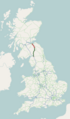 A7 road map.png 250 × 425; 48 KB
-
 A7 roadside scene - geograph.org.uk - 363426.jpg 640 × 480; 119 KB
-
 A7, Crookston - geograph.org.uk - 566396.jpg 640 × 480; 62 KB
-
 A7, North Middleton - geograph.org.uk - 1356710.jpg 640 × 480; 78 KB
-
 A7, North Middleton - geograph.org.uk - 1356885.jpg 640 × 480; 72 KB
-
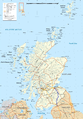 A7-road map.png 2,400 × 3,450; 6.69 MB
-
 Clerk Street (A7), Edinburgh, 10 March 2009.jpg 2,592 × 3,298; 4.72 MB
-
 Crafts Totem Pole - geograph.org.uk - 394063.jpg 481 × 640; 88 KB
-
 Entrance to Harker (geograph 3494676).jpg 640 × 480; 77 KB
-
 Failte Scottish.jpg 1,533 × 1,516; 1.01 MB
-
 Junction of minor road and the A7 - geograph.org.uk - 1184121.jpg 640 × 480; 94 KB
-

-
 Langholm, High Stree geograph-3477515-by-Ben-Brooksbank.jpg 2,332 × 1,378; 2.95 MB
-

-
 Mobile sign by the A7 - geograph.org.uk - 705208.jpg 640 × 480; 113 KB
-
 National Cycle Network route 1 - geograph.org.uk - 1569438.jpg 640 × 359; 100 KB
-
 Old A7 - geograph.org.uk - 624080.jpg 640 × 480; 62 KB
-
 Old alignment of the A7 - geograph.org.uk - 1356708.jpg 640 × 480; 94 KB
-
 Old Dalkeith Road (A7) - geograph.org.uk - 4483717.jpg 640 × 480; 76 KB
-
 Old Dalkeith Road passing Edmonstone (geograph 6800816).jpg 1,024 × 768; 304 KB
-
 Old Milestone by the A7 in Carlisle (geograph 5622987).jpg 528 × 960; 79 KB
-
 Old Milestone by the A7 in Carlisle (geograph 5622996).jpg 427 × 640; 204 KB
-
 Old Milestone by the A7 in Harker (geograph 5622998).jpg 621 × 480; 140 KB
-
 Old Milestone by the A7 in Longtown (geograph 5623002).jpg 585 × 768; 303 KB
-
 Old Milestone by the A7, Kingstown Road, Carlisle (geograph 5622997).jpg 480 × 640; 159 KB
-
 Old Milestone by the A7, near Watch Hill Wood (geograph 5623005).jpg 640 × 480; 207 KB
-
 Old Milestone by the A7, north of Blackford (geograph 5622999).jpg 558 × 480; 144 KB
-
 Old Milestone by the A7, north of Longtown (geograph 5623003).jpg 640 × 480; 192 KB
-
 Old Milestone by the A7, south of Batenbush (geograph 5623004).jpg 640 × 480; 212 KB
-
 Old Milestone by the A7, south of Longtown (geograph 5623001).jpg 640 × 480; 212 KB
-
 Old Milestone by the A7, south of Westlinton (geograph 5623000).jpg 640 × 480; 216 KB
-
 Roadside Plaque at Shank Bridge - geograph.org.uk - 761945.jpg 640 × 480; 80 KB
-
 Scotland Road, Carlisle (A7) - geograph.org.uk - 1440115.jpg 640 × 480; 79 KB
-
 Southern end of Canonbie bypass - geograph.org.uk - 332077.jpg 640 × 480; 89 KB
-
 The A7 at Dryden - geograph.org.uk - 235751.jpg 640 × 480; 87 KB
-
 The A7 at Eweslees - geograph.org.uk - 572765.jpg 640 × 480; 104 KB
-
 The A7 at Hallywell Hill - geograph.org.uk - 933557.jpg 640 × 427; 140 KB
-
 The A7 at Linhope - geograph.org.uk - 988211.jpg 640 × 427; 123 KB
-
 The A7 at The Whin - geograph.org.uk - 753460.jpg 640 × 480; 132 KB
-
 The A7 heading into Galashiels. - geograph.org.uk - 1002024.jpg 640 × 480; 77 KB
-

-
 The A7 heading south to Langholm. - geograph.org.uk - 1026309.jpg 640 × 480; 100 KB
-
 The A7 heading towards Edinburgh - geograph.org.uk - 1185397.jpg 640 × 480; 69 KB
-
 The A7 near Millees Farm - geograph.org.uk - 6637.jpg 480 × 640; 64 KB
-
 The A7 northeast of Colterscleuch - geograph.org.uk - 577314.jpg 640 × 480; 107 KB
-
 The A7 road from Bow Castle - geograph.org.uk - 703917.jpg 640 × 427; 130 KB
-
 The A7 south of Selkirk - geograph.org.uk - 1883828.jpg 683 × 1,024; 150 KB
-
 The A7 trunk road heading south. - geograph.org.uk - 932129.jpg 640 × 480; 50 KB
-

-

-

-

-
 The long and winding road - geograph.org.uk - 761829.jpg 640 × 480; 50 KB
-
 The road heading to Gorebridge - geograph.org.uk - 971316.jpg 640 × 480; 54 KB
-
 The Shank Bridge - geograph.org.uk - 761934.jpg 640 × 480; 97 KB
-
 Tollhouse by the A7 in Kingstown (geograph 6102804).jpg 640 × 427; 98 KB
-

-
 UK road A7.PNG 124 × 84; 1 KB
-
 Wind turbine blade coming south of Selkirk on A7.jpg 8,000 × 6,000; 13.43 MB
-
 Wind turbine blade coming south of Selkirk on the A7.jpg 8,000 × 6,000; 15.92 MB
-
 A7 - before the road realignment - geograph.org.uk - 299693.jpg 640 × 480; 67 KB
-
 A7 Road - geograph.org.uk - 598119.jpg 640 × 426; 103 KB
-
 A7, Langholm - geograph.org.uk - 827770.jpg 640 × 480; 109 KB
-
 The White House - geograph.org.uk - 126266.jpg 640 × 480; 211 KB


,_Edinburgh,_10_March_2009.jpg)

.jpg)


_-_geograph.org.uk_-_4483717.jpg)
.jpg)
.jpg)
.jpg)
.jpg)
.jpg)
.jpg)
.jpg)
.jpg)
.jpg)
.jpg)
.jpg)
.jpg)

_-_geograph.org.uk_-_1440115.jpg)


.jpg)
.jpg)


