Category:A handbook for travellers in India, Burma, and Ceylon (1911)
Jump to navigation
Jump to search
Media in category "A handbook for travellers in India, Burma, and Ceylon (1911)"
The following 63 files are in this category, out of 63 total.
-
 1911 Map of Benares Varanasi Uttar Pradesh India.jpg 1,246 × 1,304; 207 KB
-
 1911 map Rangoon John Murray.png 1,258 × 734; 1.35 MB
-
 A handbook for travellers in India, Burma, and Ceylon . (1911) (14594749840).jpg 1,300 × 2,494; 394 KB
-
 A handbook for travellers in India, Burma, and Ceylon . (1911) (14595110347).jpg 1,276 × 2,442; 343 KB
-
 A handbook for travellers in India, Burma, and Ceylon . (1911) (14758599126).jpg 2,432 × 1,238; 364 KB
-
 A handbook for travellers in India, Burma, and Ceylon . (1911) (14758606906).jpg 1,288 × 2,648; 472 KB
-
 A handbook for travellers in India, Burma, and Ceylon . (1911) (14778499041).jpg 1,614 × 2,202; 783 KB
-
 A handbook for travellers in India, Burma, and Ceylon . (1911) (14779237264).jpg 1,596 × 2,428; 404 KB
-
 A handbook for travellers in India, Burma, and Ceylon . (1911) (14781645685).jpg 1,388 × 2,334; 374 KB
-
 A handbook for travellers in India, Burma, and Ceylon . (1911) (14801475823).jpg 1,214 × 2,574; 389 KB
-
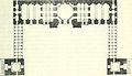
 Arhai-din-ka-jhompra Mosque at Ajmer India 1911 plan.jpg 1,156 × 1,110; 156 KB
-
 Bangalore Murray.jpg 1,329 × 1,095; 1.26 MB
-
 Bijapur Murray.jpg 2,464 × 1,616; 2.3 MB
-
 Birds view of Thyagaraja Temple Tiruvarur India.jpg 1,566 × 1,274; 290 KB
-
 Bombay 1903.jpg 2,328 × 3,032; 10.62 MB
-
 Bombay City map (1924).jpg 1,251 × 1,641; 443 KB
-
 Cashmere 1903.jpg 3,136 × 2,281; 7.37 MB
-
 Darjiling 1903.jpg 3,036 × 2,380; 3.81 MB
-
 Ground plan of Kailash Temple at Ellora Caves India.jpg 918 × 1,476; 176 KB
-
 Gwalior Fort map 1911.jpg 1,272 × 2,076; 311 KB
-
 Hampi Murray.jpg 1,446 × 1,943; 1.42 MB
-
 Hampi Ruins of Vijaynagar India Map 1911.jpg 1,346 × 1,796; 225 KB
-
 A handbook for travellers in India, Burma, and Ceylon . (IA handbooktravelle00john).pdf 695 × 1,050, 792 pages; 39.4 MB
-
 Hyderabad map 1911.jpg 1,572 × 2,356; 358 KB
-
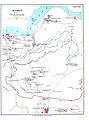
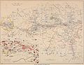
 Indian Mutiny Map Showing Position of Troops on 1st May 1857.jpg 2,388 × 1,354; 959 KB
-
 Junagadh Girnar Hill map.jpg 1,517 × 2,235; 782 KB
-
 Kanpur Cawnpur and Environ Map 1911.jpg 1,804 × 1,312; 286 KB
-
 Karachi map 1911.jpg 1,811 × 1,376; 260 KB
-
 Lahore and Environ map 1911.jpg 1,667 × 1,266; 1.83 MB
-
 Lucknow 1909.jpg 764 × 528; 258 KB
-
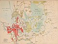
 Lucknow Intrenched Position of the British garrison map 1911.jpg 2,472 × 1,120; 237 KB
-
 Mahawara Dhelwara Cave No 5 Ellora Caves India plan.jpg 706 × 1,204; 116 KB
-
 Matheran India Map 1911.jpg 1,268 × 1,942; 261 KB
-
 Moti Masjid Agra Fort India plan.jpg 776 × 1,052; 83 KB
-
 Mussoorie 1903.jpg 2,998 × 2,304; 7.1 MB
-
 Ootacamund map 1903.jpg 3,052 × 2,352; 6.55 MB
-
 Ootacamund Ooty Map 1911.jpg 1,798 × 1,370; 284 KB
-
 Plan du fort d'Agra (1901).jpg 610 × 867; 287 KB
-
 Plan map of Lahore Fort 1911.jpg 427 × 673; 145 KB
-
 Plan of Ananda Temple Myanmar.jpg 472 × 472; 143 KB
-
 Plan of Ananda Temple Myanmar2.jpg 300 × 193; 13 KB
-
 Plan of Badami Cave.jpg 652 × 592; 63 KB
-
 Plan of Bijapur India 1911.jpg 2,320 × 1,522; 413 KB
-
 Plan of Fatehpur Sikri India.jpg 1,400 × 1,264; 248 KB
-
 Plan of Gol Gumbaz Bijapur India.jpg 806 × 872; 130 KB
-
 Plan of Mandalay Palace Myanmar.jpg 1,476 × 1,508; 209 KB
-
 Plan of Meenakshi Amman Temple Madurai India.jpg 920 × 1,412; 169 KB
-
 Plan of Neminath Jain Temple Girnar Gujarat India 1911.jpg 1,198 × 1,720; 228 KB
-
 Plan of Qutb Complex Delhi India.jpg 1,492 × 2,040; 282 KB
-
 Plan of Stupa at Sanchi India.jpg 784 × 824; 86 KB
-
 Plan of temple at Pattakal India.jpg 320 × 609; 93 KB
-
 Plan of Western Half of Jami Masjid Jaunpur India.jpg 1,330 × 762; 105 KB
-
 Poona Kirkee.jpg 565 × 901; 100 KB
-
 Pune Poona 1911 map.jpg 1,596 × 1,970; 358 KB
-
 Section of Stupa at Sanchi India.jpg 1,506 × 584; 114 KB
-
 Section of Taj Mahal (2).jpg 1,306 × 920; 144 KB
-
 Shahjahanabad or Modern Delhi 1911 map.jpg 1,328 × 1,758; 331 KB
-
 Simla 1903.jpg 3,036 × 2,343; 7.26 MB
-
 Simla and Jutogh 1911 map.jpg 1,740 × 1,346; 350 KB
-
 Srinagar and Environ map 1911.jpg 1,736 × 1,296; 284 KB
-
 Vastupal Tejpal Jain Temple plan Girnar Gujarat India.jpg 1,188 × 1,060; 130 KB
-
 Veraval Somnath Environ map 1911.jpg 1,412 × 812; 137 KB
-
 Yangon Rangoon and Environ map 1911.jpg 1,702 × 1,284; 246 KB


_(14594749840).jpg)
_(14595110347).jpg)
_(14758599126).jpg)
_(14758606906).jpg)
_(14778499041).jpg)
_(14779237264).jpg)
_(14781645685).jpg)
_(14801475823).jpg)


.jpg)


.jpg)


.jpg)


