Category:Accommodation bridge, Neston cutting
Jump to navigation
Jump to search
| Object location | | View all coordinates using: OpenStreetMap |
|---|
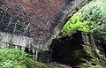
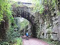
This bridge was built to preserve access to farm fields at the time of construction of the West Kirby to Hooton Line. It is not clearly apparent from old maps by which farm it was used. Seen today from above, it appears grassed over and therefore, presumably, no longer in use.
Media in category "Accommodation bridge, Neston cutting"
The following 7 files are in this category, out of 7 total.
-
 Accomodation bridge, Neston cutting 1.jpg 5,072 × 3,216; 11.07 MB
-
 Accomodation bridge, Neston cutting 2.jpg 5,024 × 3,216; 9.97 MB
-
 Accomodation bridge, Neston cutting 3.jpg 5,040 × 3,360; 12.85 MB
-
 Neston cutting (21).JPG 3,240 × 4,320; 3.9 MB
-
 Neston cutting (22).JPG 3,240 × 4,320; 4.32 MB
-
 Neston cutting (23).JPG 4,320 × 3,240; 4.81 MB
-
 Wirral Way, Little Neston - geograph.org.uk - 1200585.jpg 640 × 480; 110 KB


.JPG)
.JPG)
.JPG)
