Category:Aerial photographs of Fuerteventura
Jump to navigation
Jump to search
Subcategories
This category has only the following subcategory.
A
- Aerial views of Caleta de Fuste (12 F)
Media in category "Aerial photographs of Fuerteventura"
The following 66 files are in this category, out of 66 total.
-
 2012-01-08 15-52-07 Spain Kanarische Inseln Puerto de las Lajas.jpg 4,288 × 2,848; 1.95 MB
-
 2012-01-08 15-54-02 Spain Canarias Puerto de las Lajas.jpg 4,288 × 2,848; 2 MB
-
 2012-01-08 15-55-16 Spain Canarias Puerto del Rosario.jpg 4,288 × 2,848; 2.22 MB
-
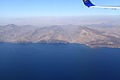
 20120108 Fuerteventura.jpg 3,000 × 1,500; 1.07 MB
-
 Aerial view of beach volleyball courts on Jandia Beach on Fuerteventura, Canary Islands.jpg 5,302 × 3,532; 18.68 MB
-
 Aerial view of Esquinzo on Fuerteventura, Canary Islands.jpg 5,464 × 3,640; 14.45 MB
-
 Aerial view of Jandia Beach and Playa del Matorral on Fuerteventura, Canary Islands.jpg 5,464 × 3,640; 13.66 MB
-
 Aerial view of ROBINSON Club Esquinzo Playa on Fuerteventura, Canary Islands.jpg 5,381 × 3,585; 14.15 MB
-
 Aerial view of Royal Palm Resort & Spa in Esquinzo on Fuerteventura, Canary Islands.jpg 5,392 × 3,592; 13.03 MB
-

-
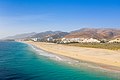
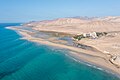
 Aerial view of the beach Esquinzo-Butihondom on Fuerteventura, Canary Islands.jpg 5,396 × 3,595; 15.81 MB
-
 Aerial view of the beach Playa del Matorral on Fuerteventura, Canary Islands.jpg 5,464 × 3,640; 14.41 MB
-
 Aerial view of the coastline of Morro Jable on Fuerteventura, Canary Islands.jpg 5,464 × 3,640; 13.58 MB
-

-
-
 Aerial view of the salt marsh Humedal Saladar de Jandia on Fuerteventura, Canary Islands.jpg 5,464 × 3,640; 14.6 MB
-
-
 Aerial view of the surfing beach Playa del Viejo Reyes on Fuerteventura, Canary Islands.jpg 5,464 × 3,640; 14.11 MB
-
 Aerial view of the town of Morro Jable on Fuerteventura, Canary Islands.jpg 5,464 × 3,640; 13.84 MB
-
 Aerial view of the town of Solana Matorral on Fuerteventura, Canary Islands.jpg 5,464 × 3,640; 14 MB
-
-

-
 Aerial view of volcanic mountains in La Pared on Fuerteventura, Canary Islands.jpg 5,338 × 3,556; 11.68 MB
-
 Caleta del Bajo (Fuerteventura).jpg 24,000 × 12,000; 69.05 MB
-
 Caleta del Bajo - Fuerteventura.jpg 24,000 × 12,000; 49.19 MB
-
 Casa Winter in Cofete on Fuerteventura, Canary Islands.jpg 4,445 × 2,961; 12.11 MB
-
 Corralejo 2007-09-15 01.jpg 3,072 × 2,304; 2.68 MB
-
 Corralejo 2007-09-15 02.jpg 3,072 × 2,304; 2.78 MB
-
 Corralejo luftbild.jpg 2,259 × 1,566; 2.87 MB
-
 Dunas Corralejo 1.jpg 2,217 × 1,427; 2.46 MB
-
 FlughafenFuertaventura.JPG 2,592 × 1,944; 1.72 MB
-
 Fuerteventura, carreteras 1993.jpg 1,068 × 706; 680 KB
-
 Hotel area in Esquinzo on Fuerteventura, Canary Islands.jpg 5,185 × 3,454; 14.12 MB
-
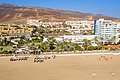
 Hotels along Playa Morro Jable on Fuerteventura, Canary Islands.jpg 5,464 × 3,640; 15.83 MB
-
 Hotels in Esquinzo on Fuerteventura, Canary Islands.jpg 5,393 × 3,593; 13.44 MB
-
 Luftbild Barlovento, Hotel in Costa Calma.jpg 5,464 × 3,640; 10.67 MB
-
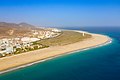
 Luftbild Costa Calma mit Strand und Hotels.jpg 5,464 × 3,640; 11.56 MB
-
 Luftbild El Cotillo mit Castillo de El Toston, Westküste - 51499994362.jpg 5,464 × 3,640; 9.09 MB
-
 Luftbild Felsen von La Pared - 51495046867.jpg 5,464 × 3,640; 9.04 MB
-
 Luftbild Felsen von La Pared.jpg 4,722 × 3,146; 6.56 MB
-
 Luftbild Jogger am Strand von Fuerteventura.jpg 3,931 × 2,619; 4.8 MB
-
 Luftbild La Pared.jpg 5,464 × 3,640; 7.78 MB
-
 Luftbild Morro Jable mit Strand und Leuchtturm - 51495613343.jpg 5,464 × 3,640; 9.27 MB
-
 Luftbild Playa de Sotavento, Lagune - 51511166127.jpg 3,255 × 3,255; 4.47 MB
-
 Luftbild Playa de Sotavento, Lagune - 51512665394.jpg 5,464 × 3,640; 7.79 MB
-
 Luftbild Playa de Sotavento, Lagune - 51512711614.jpg 3,429 × 2,284; 3.3 MB
-
 Luftbild Playa de Sotavento, Lagune - 51512915455.jpg 5,464 × 3,640; 7.85 MB
-
 Luftbild Playa de Sotavento, Lagune.jpg 3,640 × 3,640; 5.13 MB
-
 Luftbild Sonnenuntergang in Costa Calma.jpg 5,464 × 3,640; 6.84 MB
-
 Luftbild Strand von El Cotillo, Westküste - 51500008632.jpg 5,464 × 3,640; 9.36 MB
-
 Luftbild Strand von El Cotillo, Westküste - 51500665151.jpg 2,425 × 3,640; 3.85 MB
-
 Luftbild Strand von El Cotillo, Westküste - 51500903888.jpg 5,464 × 3,640; 8.3 MB
-
 Luftbild Strand von El Cotillo, Westküste - 51500918628.jpg 5,464 × 3,640; 8.01 MB
-
 Luftbild Strand von La Pared.jpg 5,464 × 3,640; 9.32 MB
-
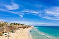
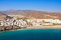
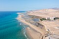
 Playa Esquinzo-Butihondom on Fuerteventura, Canary Islands - 51121882753.jpg 5,035 × 3,354; 11.4 MB
-
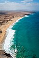
 Playa Esquinzo-Butihondom on Fuerteventura, Canary Islands.jpg 5,270 × 3,511; 14.66 MB
-
 Puerto del Rosario - airport (aireal) 01 ies.jpg 5,616 × 3,744; 5.94 MB
-
 Pájara - FV-2+Barranco Vanchuelo Grande (aireal) 01 ies.jpg 5,616 × 3,744; 7.02 MB
-
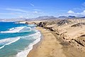
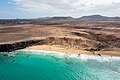
 Pájara coast (aireal) 01 ies.jpg 5,616 × 3,744; 6.22 MB
-
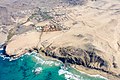
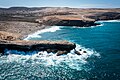
 Pájara coast (aireal) 02 ies.jpg 5,616 × 3,744; 7.38 MB
-
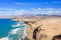
 Pájara coast - Puerto de la Torre and Barranco de la Torre (aireal) 01 ies.jpg 5,616 × 3,744; 7.89 MB
-
 Pájara coast - Puerto de la Torre and Barranco de la Torre (aireal) 02 ies.jpg 5,616 × 3,744; 8.34 MB
-
 Top down aerial of the beach Esquinzo-Butihondom on Fuerteventura, Canary Islands.jpg 5,464 × 3,640; 12.6 MB
-
 Top-down areal of the famous surfing spot Playa del Viejo Reyes in la Pared on Fuerteventura.jpg 5,464 × 3,640; 13.79 MB
-
 Top-down areal of the surfing beach Playa del Viejo Reyes on Fuerteventura, Canary Islands.jpg 5,464 × 3,070; 12.04 MB
-
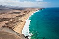
 Water sports at the beach Esquinzo-Butihondom on Fuerteventura, Canary Islands.jpg 5,420 × 3,045; 10.17 MB


.jpg)


_01_ies.jpg)
_01_ies.jpg)
_01_ies.jpg)
_02_ies.jpg)
_01_ies.jpg)
_02_ies.jpg)


