Category:Aerial photographs of Limburg (Netherlands)
Jump to navigation
Jump to search
Provinces of the Netherlands: Drenthe · Flevoland · Friesland · Gelderland · Groningen · Limburg · North Brabant · North Holland · Overijssel · South Holland · Utrecht · Zeeland
Subcategories
This category has the following 6 subcategories, out of 6 total.
G
- Aerial photographs of Gennep (7 F)
M
- Aerial photographs of Maastricht (186 F)
R
S
V
- Aerial photographs of Venlo (31 F)
Media in category "Aerial photographs of Limburg (Netherlands)"
The following 75 files are in this category, out of 75 total.
-
 America drone panorama.jpg 1,500 × 1,125; 1.57 MB
-
 Broekhuizen drone panorama.jpg 1,500 × 980; 1.56 MB
-
 Broekhuizen drone.jpg 1,350 × 1,800; 2.67 MB
-
 Broekhuizenvorst drone panorama.jpg 2,788 × 3,280; 6.95 MB
-
 Griendtsveen panorama.jpg 1,500 × 1,015; 1.54 MB
-
 Grubbenvorst drone panorama.jpg 1,500 × 1,125; 1.86 MB
-
 Hegelsom drone panorama.jpg 1,500 × 1,125; 631 KB
-
 Horst city centre drone.jpg 1,500 × 823; 1.38 MB
-
 Horst city centre from above.jpg 1,500 × 971; 1.78 MB
-

-
 Kasteel met bijgebouwen in omringend landschap - Overeys - 20398976 - RCE.jpg 1,188 × 1,200; 323 KB
-
 Kasteelhoensbroek.jpg 557 × 556; 140 KB
-
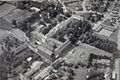
 KLMAerocarto-37355-Caestert-(BE)-1965.jpg 1,000 × 728; 147 KB
-
 Knooppunt Kruisdonk Beeldbank.jpg 451 × 420; 29 KB
-
 Kronenberg drone panorama.jpg 1,500 × 1,125; 1.71 MB
-
 Lottum drone panorama.jpg 1,500 × 1,125; 1.54 MB
-
 Luchtfoto - Geysteren - 20077808 - RCE.jpg 1,200 × 914; 318 KB
-
 Luchtfoto - Vaals - 20374578 - RCE.jpg 1,200 × 799; 295 KB
-
 Luchtfoto nr. 32597 - Unknown - 20497405 - RCE.jpg 1,200 × 900; 198 KB
-
 Luchtfoto repro - Lottum - 20471041 - RCE.jpg 1,200 × 900; 136 KB
-
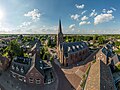
 Luchtfoto Thorn Abdijkerk WBrouns.jpg 1,280 × 960; 348 KB
-
 Luchtopname. DAF personenwagenfabriek te Born, Bestanddeelnr 168-0490.jpg 2,541 × 2,553; 1.34 MB
-
 Makado - Beek.jpg 1,883 × 1,347; 736 KB
-
 Meerlo panorama.jpg 1,500 × 1,060; 1.37 MB
-
 Melderslo panorama.jpg 1,500 × 1,042; 1.42 MB
-
 Meterik drone panorama.jpg 1,500 × 1,125; 1.51 MB
-

-
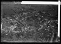
 NIMH - 2011 - 0335 - Aerial photograph of Meerssen, The Netherlands - 1920 - 1940.jpg 3,500 × 2,598; 2.37 MB
-
 NIMH - 2011 - 0336 - Aerial photograph of Meerssen, The Netherlands - 1920 - 1940.jpg 3,500 × 2,508; 2.18 MB
-
 NIMH - 2011 - 0407 - Aerial photograph of Panheel, The Netherlands - 1920 - 1940.jpg 3,500 × 2,579; 1.72 MB
-
 NIMH - 2011 - 0533 - Aerial photograph of Vaals, The Netherlands - 1920 - 1940.jpg 3,500 × 2,549; 2.1 MB
-
 NIMH - 2011 - 0534 - Aerial photograph of Vaals, The Netherlands - 1920 - 1940.jpg 3,500 × 2,523; 2.11 MB
-

-

-
 NIMH - 2011 - 0552 - Aerial photograph of Echt, Limburg, The Netherlands - 1920 - 1940.jpg 3,500 × 2,540; 1.85 MB
-

-
 NIMH - 2011 - 0814 - Aerial photograph of Blitterswijk, The Netherlands - 1920 - 1940.jpg 3,500 × 2,524; 3.02 MB
-

-
 NIMH - 2011 - 0835 - Aerial photograph of Limbricht, The Netherlands - 1920 - 1940.jpg 3,500 × 2,559; 2.56 MB
-
 NIMH - 2011 - 0840 - Aerial photograph of Mheer, The Netherlands - 1920 - 1940.jpg 3,500 × 2,446; 2.42 MB
-
 NIMH - 2011 - 0858 - Aerial photograph of Well, The Netherlands - 1920 - 1940.jpg 3,500 × 2,542; 2.92 MB
-

-
 NIMH - 2011 - 1016 - Aerial photograph of Mookerschans, The Netherlands - 1920 - 1940.jpg 3,500 × 2,583; 2.53 MB
-

-
 NIMH - 2011 - 2071 - Aerial photograph of Willem-Sophia mijn, The Netherlands.jpg 3,500 × 2,541; 2.07 MB
-
 NIMH - 2011 - 3636 - Aerial photograph of Panheel, The Netherlands.jpg 3,500 × 2,599; 1.97 MB
-
 NIMH - 2011 - 5258 - Aerial photograph of Vaals, The Netherlands.jpg 4,000 × 2,687; 2.97 MB
-
 NIMH - 2011 - 5259 - Aerial photograph of Vaals, The Netherlands.jpg 4,000 × 2,666; 2.65 MB
-
 NIMH - 2011 - 5262 - Aerial photograph of Vaals, The Netherlands.jpg 4,000 × 2,896; 2.3 MB
-
 NIMH - 2011 - 5263 - Aerial photograph of Vaals, The Netherlands.jpg 4,000 × 2,823; 2.6 MB
-
 NIMH - 2011 - 5264 - Aerial photograph of Vaals, The Netherlands.jpg 4,000 × 2,830; 2.53 MB
-
 NIMH - 2011 - 5265 - Aerial photograph of Vaals, The Netherlands.jpg 4,000 × 2,824; 2.41 MB
-
 NIMH - 2011 - 5266 - Aerial photograph of Vaals, The Netherlands.jpg 4,000 × 2,759; 2.75 MB
-
 NIMH - 2011 - 5278 - Aerial photograph of Vaals, The Netherlands.jpg 4,000 × 2,731; 2.63 MB
-
 NIMH - 2011 - 5279 - Aerial photograph of Vaals, The Netherlands.jpg 4,000 × 2,656; 2.16 MB
-
 NIMH - 2011 - 9900-013 - Aerial photograph of Baarlo, The Netherlands.jpg 4,000 × 2,764; 2.5 MB
-
 NIMH - 2011 - 9903-22-03 - Aerial photograph of Valkenburg, The Netherlands.jpg 4,000 × 2,643; 2.08 MB
-
 NIMH - 2155 000079 - Aerial photograph of Afferden, The Netherlands.jpg 3,520 × 2,367; 1.89 MB
-
 NIMH - 2155 008961 - Aerial photograph of Hemense Schans, The Netherlands.jpg 3,520 × 2,438; 1.82 MB
-
 NIMH - 2155 012250 - Aerial photograph of Kessel, The Netherlands.jpg 3,520 × 2,332; 1.42 MB
-
 NIMH - 2155 012251 - Aerial photograph of Kessel, The Netherlands.jpg 3,520 × 2,395; 1.61 MB
-
 NIMH - 2155 013876 - Aerial photograph of Mheer, The Netherlands.jpg 3,520 × 2,302; 1.77 MB
-
 NIMH - 2155 042917 - Aerial photograph of Vaals, The Netherlands.jpg 5,114 × 3,318; 4.28 MB
-
 NIMH - 2155 042918 - Aerial photograph of Vaals, The Netherlands.jpg 5,211 × 3,493; 4.32 MB
-
 NIMH - 2155 042919 - Aerial photograph of Vaals, The Netherlands.jpg 5,211 × 3,513; 3.98 MB
-
 NIMH - 2155 072485 - Aerial photograph of Griendsveen, The Netherlands.jpg 4,000 × 1,992; 2.3 MB
-
 NIMH - 2011 - 0406 - Aerial photograph of Panheel, The Netherlands - 1920 - 1940.jpg 3,500 × 2,542; 1.88 MB
-
 RodaStadion.jpg 400 × 267; 33 KB
-
 Schloss Lemiers Luftbild.jpg 1,139 × 835; 378 KB
-
 Sevenum drone panorama sun.jpg 1,500 × 1,125; 1.64 MB
-
 Sevenum drone panorama.jpg 1,500 × 1,125; 1.62 MB
-
 Sintermeerten oud800.jpg 800 × 557; 456 KB
-
 Swolgen drone panorama.jpg 1,500 × 1,125; 1.16 MB
-
 Tienray panorama.jpg 1,500 × 1,103; 1.55 MB
-
 View on Kasen.jpg 2,224 × 1,480; 582 KB


-1965.jpg)


