Category:Agbogbloshie
Jump to navigation
Jump to search
| Object location | | View all coordinates using: OpenStreetMap |
|---|
commercial district in the Old Fadama (Ayaalolo) slum of Accra, Ghana, known for its e-waste dump issues  | |||||
| Upload media | |||||
| Instance of |
| ||||
|---|---|---|---|---|---|
| Location | Accra, Greater Accra Region, Ghana | ||||
| Located in or next to body of water | |||||
 | |||||
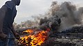
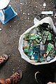
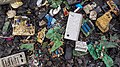
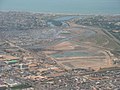
Today is Agbogbloshie a township of Accra and is located on a part of the wetlands of the Korle Lagoon. The place is notorious for the giant disposal site for electronic waste from the European countries which is located there. Nevertheless is Agbogbloshie classified at the present time by the metropolitan authorities of Accra as "2nd Class Residential Area" - a very friendly classification as urban living room for humans in the light of this air and ground dirtying garbage dump.
Media in category "Agbogbloshie"
The following 32 files are in this category, out of 32 total.
-
 Agbobloshie 2.png 640 × 480; 469 KB
-
 Agbogbloshie Ghana.jpg 5,184 × 3,456; 6.79 MB
-
 Agbogbloshie o.jpg 2,462 × 3,283; 2.19 MB
-
Agbogbloshie September 2017.webm 1 min 43 s, 640 × 480; 61.88 MB
-
 Agbogbloshie waste.jpg 2,400 × 2,400; 2.78 MB
-
 Agbogbloshie, Ghana - September 2019.jpg 7,952 × 5,304; 24.32 MB
-
 Agbogbloshie, Ghana 2019.jpg 5,946 × 3,436; 12.73 MB
-
 Agbogbloshie, Ghana.jpg 4,032 × 2,268; 3.78 MB
-
 Agbogbloshie.JPG 3,456 × 2,592; 733 KB
-
 Agbogbloshie.png 640 × 480; 430 KB
-
 Corn vendor in Ghana (5927490622).jpg 3,264 × 2,448; 2.8 MB
-
 Day 4 Agbogloshie (24893077287).jpg 5,472 × 3,648; 5.45 MB
-
 Day 4 Agbogloshie (24893082937).jpg 5,472 × 3,648; 10.5 MB
-
 Day 4 Agbogloshie (24893091067).jpg 5,472 × 3,648; 5.78 MB
-
 Day 4 Agbogloshie (25891018478).jpg 5,472 × 3,648; 6.17 MB
-
 Day 4 Agbogloshie (25891021398).jpg 3,648 × 5,472; 5.74 MB
-
 Day 4 Agbogloshie (25891026808).jpg 5,472 × 3,648; 6.11 MB
-
 Day 4 Agbogloshie (25891029818).jpg 3,648 × 5,472; 5.81 MB
-
 Day 4 Agbogloshie (25891037538).jpg 5,472 × 3,648; 7.22 MB
-
 Day 4 Agbogloshie (25891043908).jpg 5,472 × 3,648; 6.87 MB
-
 Day 4 Agbogloshie (39731037672).jpg 5,472 × 3,072; 6.48 MB
-
 Day 4 Agbogloshie (39731039512).jpg 5,472 × 3,648; 12.51 MB
-
 Day 4 Agbogloshie (39763154511).jpg 5,472 × 3,648; 6.25 MB
-
 Décharge Agbogbloshie.jpg 4,608 × 3,456; 6.5 MB
-
 Décharge agbogbloshie.jpg 4,608 × 3,456; 8.64 MB
-
 Décharge.jpg 4,608 × 3,456; 1.72 MB
-
E-waste - Cleaning Up The World's Fastest-Growing Trash Problem.webm 8 min 37 s, 1,920 × 1,080; 207.77 MB
-
 E-waste workers.jpg 2,048 × 1,536; 707 KB
-
 Electronic waste at Agbogbloshie, Ghana.jpg 4,032 × 2,268; 7.08 MB
-
 Korle Lagoon.jpg 1,024 × 768; 432 KB
-
Reality of Copper Burning (E-waste mining in Agbogbloshie, 2016).webm 2 min 10 s, 1,920 × 1,080; 43.9 MB
-
Toxins in Agbogbloshie.webm 1 min 18 s, 1,920 × 1,080; 39.64 MB


.jpg)
.jpg)
.jpg)
.jpg)
.jpg)
.jpg)
.jpg)
.jpg)
.jpg)
.jpg)
.jpg)
.jpg)
.jpg)


