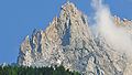
Category:Aiguille des Grands Charmoz
Vai alla navigazione
Vai alla ricerca
mountain  | |||||
| Carica un file multimediale | |||||
| Istanza di | |||||
|---|---|---|---|---|---|
| Luogo | Alta Savoia, Alvernia-Rodano-Alpi, Francia metropolitana, Francia | ||||
| Catena montuosa | |||||
| Prominenza topografica |
| ||||
| Isolamento topografico |
| ||||
| Altezza sul mare |
| ||||
 | |||||
Sottocategorie
Questa categoria contiene un'unica sottocategoria, indicata di seguito.
File nella categoria "Aiguille des Grands Charmoz"
Questa categoria contiene 47 file, indicati di seguito, su un totale di 47.
-
 01 Chamonix-Mont-Blanc - Mer de Glace 2.JPG 1 600 × 1 200; 1,31 MB
-
 Aiguille des Grands Charmoz north face.jpg 1 280 × 960; 193 KB
-
 Aiguille des Grands Charmoz, Aiguille du Grépon.JPG 3 412 × 2 308; 4,19 MB
-
 Aiguille des Grands Charmoz.JPG 3 264 × 1 840; 3,31 MB
-
 Aiguille du Dru and Aiguille Verte from the Montenvers, Chamonix.jpg 8 727 × 3 180; 12,08 MB
-
 Aiguille du Grépon & Aiguille des Grands Charmoz from La Flégère 2.JPG 3 456 × 5 184; 6,89 MB
-
 Aiguille du Grépon & Aiguille des Grands Charmoz from La Flégère.JPG 5 184 × 3 456; 7,14 MB
-
 Aiguilles de Chamonix from La Flégère.JPG 5 184 × 3 456; 2,84 MB
-
 Alpenlandschap, RP-F-00-2481.jpg 4 848 × 6 232; 2,71 MB
-
 Alps CNE-v1-p154-A.jpg 2 118 × 1 348; 1,22 MB
-
 Bergweg door de Alpen, RP-F-F01162-BJ.jpg 951 × 796; 105 KB
-
 CH-NB - À la Flégère - Collection Gugelmann - GS-GUGE-13-103.tif 8 189 × 5 984; 186,95 MB
-
 CH-NB Photoglob-Wehrli EAD-WEHR-32070-B.tiff 4 772 × 3 639; 16,59 MB
-
 CH-NB Photoglob-Wehrli EAD-WEHR-32075-B.tiff 4 734 × 3 642; 16,48 MB
-
 CH-NB Photoglob-Wehrli EAD-WEHR-32078-B.tiff 4 763 × 3 625; 16,5 MB
-
 CH-NB Photoglob-Wehrli EAD-WEHR-32124-B.tiff 4 763 × 3 637; 16,55 MB
-
 Chamonix (1983) 08.jpg 710 × 1 067; 800 KB
-
 Chamonix (1983) 09.jpg 675 × 1 019; 958 KB
-
 Chamonix (1983) 11.jpg 681 × 1 017; 537 KB
-
 Chamonix - panoramio (3).jpg 4 000 × 3 000; 1,98 MB
-
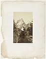
 Ernst Platz, Aiguille des Grands Charmoz.jpg 331 × 472; 26 KB
-
 ETH-BIB-Aiguille de Grepon, Mer de Glace-LBS H1-024990.tif 6 460 × 4 511; 83,41 MB
-
 ETH-BIB-Aiguilles-Charmoz-Grépond von Montanvers-Dia 247-07073 (cropped).tif 2 034 × 3 127; 6,08 MB
-
 ETH-BIB-Aiguilles-Charmoz-Grépond von Montanvers-Dia 247-07073.tif 3 093 × 3 590; 10,67 MB
-

-

-

-
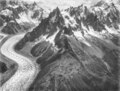
 Glacial valley of Mer de Glace from la Flégère.JPG 5 184 × 3 456; 4,54 MB
-
 Glacier des Bois, near Le Chapeau LCCN94513953 (cropped).jpg 3 064 × 2 639; 1,83 MB
-
 Glacier des Bois, near Le Chapeau LCCN94513953.jpg 3 312 × 3 051; 1,93 MB
-
 Glacier des Bois, near Le Chapeau LCCN94513953.tif 3 323 × 3 069; 9,73 MB
-
 Glacier des Nantillons.jpg 2 000 × 1 500; 819 KB
-
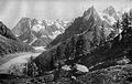
 GrandsCharmozEtGrépon.jpg 600 × 450; 79 KB
-
 Harper's New Monthly Magazine Volume 145 June to November 1922 (1922) (14742716436).jpg 4 742 × 2 896; 2,71 MB
-
-
 Horror und Delight-Turner-The Mer de Glace, Looking up to the Aiguille de Tacul DSC2115.jpg 4 879 × 3 711; 15,53 MB
-
 Jean-Antoine Linck Glacier c1799.jpg 2 000 × 1 478; 483 KB
-
 La mer de glace (août 1992).jpg 7 200 × 4 460; 3,53 MB
-
 La mer de glace aout 2012 - panoramio (1).jpg 4 000 × 3 000; 1,98 MB
-
 La voie férrée pour aller à la mer de glasse.JPG 2 560 × 1 920; 1,72 MB
-
 Mer de glace.jpg 2 118 × 2 389; 771 KB
-
 My Climbs in the Alps and Caucasus, plate 7.jpg 426 × 626; 77 KB
-
 Mêr de Glace, Valley of Chamouni-Savoy (Liber Studiorum, part X, plate 50) MET DP821483.jpg 2 627 × 2 009; 1,92 MB
-
 Mêr de Glace, Valley of Chamouni-Savoy (Liber Studiorum, part X, plate 50) MET DP847237.jpg 3 559 × 2 686; 3,35 MB
-
 NantillonsGrandsCharmozGrépon.jpg 600 × 450; 70 KB
-
 PublicTMB.jpg 2 048 × 1 536; 1,34 MB
-


_08.jpg)
_09.jpg)
_11.jpg)
.jpg)

_(titel_op_object)_La_Suisse_et_la_Savoie_(serietitel),_RP-F-F06444.jpg)
,_RP-F-F08023.jpg)
,_RP-F-F07835.jpg)

.jpg)


_(14742716436).jpg)
.jpg)


.jpg)
.jpg)


_MET_DP821483.jpg)
_MET_DP847237.jpg)


_Herinnering_aan_Chamonix-Mont-Blanc_(serietitel)_Museum_du_Mont-Blanc_(serietitel),_RP-P-1906-540.jpg)