Category:Aircraft accident altitude diagrams
Jump to navigation
Jump to search
Media in category "Aircraft accident altitude diagrams"
The following 26 files are in this category, out of 26 total.
-
 Alaska Airlines Flight 60 route.jpg 1,000 × 453; 41 KB
-
 Altitude Chart for Flight 4U9525 register D-AIPX german.png 3,040 × 1,569; 37 KB
-
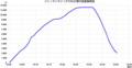 Altitude Chart for Flight 4U9525 register D-AIPX japanese.png 3,040 × 1,569; 46 KB
-
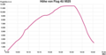
 Altitude Chart for Flight 4U9525 register D-AIPX.jpg 692 × 411; 31 KB
-
 Altitude Chart for Flight 4U9525 register D-AIPX.png 3,040 × 1,569; 33 KB
-
 Altitude Chart for Flight 4U9525 register D-AIPX.svg 512 × 265; 50 KB
-
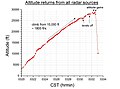
 Altitude Data sm.png 449 × 373; 11 KB
-
 Ansett New Zealand flight 703 descent graph.png 1,322 × 995; 189 KB
-
 Ansett New Zealand Flight 703 Descent Graph.png 1,553 × 913; 206 KB
-
 Diagram of Dan Air Boeing 707-321C G-BEBP.png 1,883 × 831; 489 KB
-
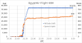 EgyptAir Flight 804 Speed and Altitude.svg 618 × 324; 291 KB
-
 Flight Pk-661 altitude data.png 984 × 433; 7 KB
-
 Flight PK-661 Altitude Data.png 1,280 × 563; 8 KB
-
 Flight profile of China Airlines flight 140.jpg 1,000 × 631; 94 KB
-
 Invicta-International-Airways-Flug 435 Flugunfall.png 1,500 × 1,056; 249 KB
-
 LaMia Airlines Flight 2933 Speed and Altitude 15 minutes.svg 618 × 388; 50 KB
-
 Le Bourget 1973 en.jpg 1,280 × 335; 113 KB
-
 Le Bourget 1973.jpg 1,280 × 335; 110 KB
-
 Sriwijaya Air Flight 182 Speed and Altitude.svg 988 × 579; 86 KB
-
 Starwood Management LLC Learjet 25 N345MC Altitude and speed profile.jpg 975 × 734; 122 KB
-
 Starwood Management LLC Learjet 25 N345MC Altitude profile.jpg 975 × 725; 107 KB
-
 TAN-SAHSA Flight 414 route.jpg 550 × 419; 45 KB
-
 Tu144 Le Bourget en.svg 1,280 × 335; 37 KB
-
 Ua93altitude.jpg 897 × 757; 137 KB
-
 Ukraine International Airlines Flight 752 speed and altitude.svg 988 × 573; 28 KB
-
 YR-BNP timeline.png 840 × 600; 23 KB


