Category:April 2011 in York
Jump to navigation
Jump to search
Deutsch: Bilder, die im April 2011 in York aufgenommen worden sind. Bitte beachten Sie, dass dies weder das Datum des Uploads noch das Datum des Scannens eines Fotos ist.
English: Images/pictures taken in York during April 2011. Note this is not the date of the upload, nor the date a photo was scanned.
Español: Fotografías o imágenes tomadas en York durante abril 2011. No es la fecha de subida ni escaneo, sino la fecha en que las fotografías o imágenes se crearon.
Esperanto: Bildoj faritaj en York en aprilo 2011. Tio ne estas la dato, kiam la bildoj estis alŝutitaj aŭ skanitaj.
Français : Photographies ou images prises en York durant avril 2011. Ce n'est pas la date du téléchargement ou du scan.
Galego: Fotografías ou imaxes tomadas en York durante abril 2011. Non é a data de subida nin escaneamento, senón a data na que se crearon as fotografías ou imaxes.
Italiano: Fotografie o immagini scattate a York nel aprile 2011. Nota bene: la data non si riferisce né a quella di upload né a quella in cui la foto è stata digitalizzata.
Norsk bokmål: Bilder tatt i York i løpet av april 2011. Merk at dette ikke er datoen for opplasting, eller når et bilde har blitt skannet.
Norsk nynorsk: Bilete teke i York i løpet av april 2011. Merk at dette ikkje er datoen for opplasting, eller når eit bilete har vorte skanna.
Русский: Изображения, сделанные в York в течение апрель 2011 (не дата загрузки изображения).
Українська: Зображення, зроблені в York протягом квітень 2011. Зауважте, що це не дата завантаження чи дата сканування фотографії.
| April 2010 | ← | April 2011 | → | April 2012 | |||||||
| Jan | Feb | Mar | Apr | May | Jun | Jul | Aug | Sep | Oct | Nov | Dec |
| 50 | 252 | 179 | 295 | 144 | 74 | 192 | 416 | 162 | 361 | 59 | 237 |
|---|---|---|---|---|---|---|---|---|---|---|---|
Media in category "April 2011 in York"
The following 200 files are in this category, out of 295 total.
(previous page) (next page)-
 A garden for Ron Weir - geograph.org.uk - 2346200.jpg 480 × 640; 143 KB
-
 A1079 towards Wilberfoss - geograph.org.uk - 2371876.jpg 1,600 × 1,200; 541 KB
-
 A1079 towards York - geograph.org.uk - 2384042.jpg 1,600 × 1,200; 511 KB
-
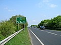
 A1237 approaching roundabout - geograph.org.uk - 2384549.jpg 1,600 × 1,200; 376 KB
-
 A1237 near Haxby - geograph.org.uk - 2384770.jpg 1,600 × 1,200; 444 KB
-
 A166 towards Stamford Bridge - geograph.org.uk - 2372493.jpg 1,600 × 1,200; 526 KB
-
 A64 heading south - geograph.org.uk - 2384404.jpg 1,600 × 1,200; 408 KB
-
 A64 towards York - geograph.org.uk - 2372240.jpg 1,600 × 1,200; 483 KB
-
 Along a fence - geograph.org.uk - 4769052.jpg 640 × 480; 111 KB
-
 Archway in city wall across Station Road - geograph.org.uk - 2364565.jpg 800 × 533; 108 KB
-
 B1228 towards York - geograph.org.uk - 2359373.jpg 1,600 × 1,200; 481 KB
-
 B1363 heading south - geograph.org.uk - 2384748.jpg 1,600 × 1,200; 494 KB
-
 Bad Bargain Lane - geograph.org.uk - 2384456.jpg 640 × 480; 61 KB
-
 Beck off Moor Lane - geograph.org.uk - 2384437.jpg 1,600 × 1,200; 565 KB
-
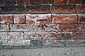
 Benchmark on archway pier of Micklegate Bar - geograph.org.uk - 2361466.jpg 683 × 1,024; 177 KB
-
-

-
 Benchmark on Rock Church, Priory Street - geograph.org.uk - 2361531.jpg 1,024 × 683; 241 KB
-
-
-

-

-
-
 Benchmark on tower buttress of St Denys Walmgate - geograph.org.uk - 2362053.jpg 1,024 × 683; 230 KB
-
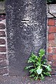
 Benchmark on wall of Toft Green - geograph.org.uk - 2361391.jpg 800 × 533; 188 KB
-
 Benchmark on wall of ^5 South Esplanade - geograph.org.uk - 2361938.jpg 1,024 × 683; 226 KB
-
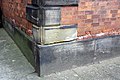
 Benchmark on Waterstones, High Ousegate - geograph.org.uk - 2361818.jpg 1,024 × 837; 270 KB
-
 Benchmark on ^45 Micklegate - geograph.org.uk - 2361571.jpg 1,024 × 683; 217 KB
-
 Benchmark on ^9 Tower Place - geograph.org.uk - 2362013.jpg 800 × 533; 160 KB
-
 Berrick Saul and Central Hall - geograph.org.uk - 2346173.jpg 480 × 640; 111 KB
-
 Biology - geograph.org.uk - 2345706.jpg 640 × 480; 86 KB
-
 Blackwood Farm - geograph.org.uk - 2375351.jpg 427 × 640; 251 KB
-
 Boundary Fence, Elvington Airfield - geograph.org.uk - 2375085.jpg 427 × 640; 261 KB
-
 Boundary Fence, Elvington Airfield - geograph.org.uk - 2375116.jpg 640 × 427; 274 KB
-
 Brecks Farm - geograph.org.uk - 2384750.jpg 1,600 × 1,200; 301 KB
-
 Bridge over the Foss (5632658795).jpg 4,928 × 3,264; 3.63 MB
-
 Bridleway heading north - geograph.org.uk - 2384579.jpg 1,600 × 1,200; 503 KB
-
 Bridleway near Langwith Lodge - geograph.org.uk - 2384932.jpg 1,600 × 1,200; 372 KB
-
 Bridleway through Rabbit Warren - geograph.org.uk - 2384066.jpg 1,600 × 1,200; 799 KB
-
 Building work starting - geograph.org.uk - 2376503.jpg 640 × 480; 110 KB
-
 Buildings on the SW side of Leeman Road - geograph.org.uk - 2364635.jpg 1,024 × 683; 139 KB
-

-
 Chemistry A Block and Chemistry Bridge - geograph.org.uk - 4719065.jpg 640 × 480; 108 KB
-
 Christ Church, Stockton Lane - geograph.org.uk - 2384494.jpg 1,600 × 1,200; 458 KB
-
 Church Lane, Wheldrake - geograph.org.uk - 2359424.jpg 1,600 × 1,200; 314 KB
-
 Church on Melrosegate, York - geograph.org.uk - 2384905.jpg 1,600 × 1,200; 509 KB
-
 City Walls - Jewbury - geograph.org.uk - 2356219.jpg 640 × 480; 140 KB
-
 City walls in Spring - geograph.org.uk - 2356228.jpg 640 × 480; 156 KB
-
 City Walls near Foss Islands - geograph.org.uk - 2356224.jpg 640 × 480; 142 KB
-
 Cloisters Walk - geograph.org.uk - 2356241.jpg 480 × 640; 147 KB
-
 Communications mast near the A1237 - geograph.org.uk - 2384773.jpg 1,263 × 1,600; 303 KB
-
 Construction compound - geograph.org.uk - 2418031.jpg 640 × 480; 118 KB
-
 Corner of Askham Bryan Agricultural College - geograph.org.uk - 2360583.jpg 4,320 × 3,240; 3.54 MB
-
 Cottages, York Street, Dunnington - geograph.org.uk - 2383995.jpg 1,024 × 686; 173 KB
-
 Crop field off Bad Bargain Lane - geograph.org.uk - 2384449.jpg 1,600 × 1,200; 506 KB
-
 Cross Keys, Dunnington - geograph.org.uk - 2383923.jpg 1,600 × 938; 215 KB
-
 Cycle parking in James College - geograph.org.uk - 4753127.jpg 640 × 480; 116 KB
-
 Cycle parking next to G022 - geograph.org.uk - 4753160.jpg 640 × 480; 140 KB
-
 Cycle path beside Malton Road - geograph.org.uk - 2384892.jpg 1,600 × 1,200; 602 KB
-
 Cycle path near A1237 roundabout - geograph.org.uk - 2384760.jpg 1,600 × 1,200; 465 KB
-
 D block from Wentworth Bridge - geograph.org.uk - 4753914.jpg 640 × 480; 80 KB
-
 Damaged benchmark on All Saints Church - geograph.org.uk - 2360941.jpg 800 × 533; 158 KB
-
-
 Damhill Wood - geograph.org.uk - 2384591.jpg 1,600 × 1,200; 416 KB
-
 Digging holes - geograph.org.uk - 4769056.jpg 640 × 480; 125 KB
-

-
 Ditch, Langwith Great Wood - geograph.org.uk - 2375113.jpg 427 × 640; 300 KB
-
 Ditch, Wheldrake Wood - geograph.org.uk - 2375100.jpg 427 × 640; 309 KB
-
 Do not feed the geese^ - geograph.org.uk - 2408770.jpg 480 × 640; 75 KB
-

-
 Dovecote Close, Wheldrake - geograph.org.uk - 2359413.jpg 1,600 × 1,200; 448 KB
-
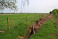
 Drainage ditch beside Langwith Stray - geograph.org.uk - 2384930.jpg 1,600 × 1,200; 763 KB
-
 Drainage ditch of Townthorpe Road - geograph.org.uk - 2384682.jpg 1,600 × 1,200; 875 KB
-
 Drainage ditch off Greengales Lane - geograph.org.uk - 2359393.jpg 640 × 480; 92 KB
-
 Drainage ditch off Low Lane - geograph.org.uk - 2384911.jpg 1,600 × 1,200; 612 KB
-
 DRS Class 66s at York.jpg 2,612 × 1,396; 2.71 MB
-
 Duck pond, Holtby - geograph.org.uk - 2372461.jpg 1,600 × 1,200; 822 KB
-
 East Lake - geograph.org.uk - 2363167.jpg 640 × 360; 93 KB
-
 Entrance to grenade ranges, Towthorpe Common - geograph.org.uk - 2384612.jpg 1,600 × 1,200; 603 KB
-
 Entrance to recreation ground, Elvington - geograph.org.uk - 2359369.jpg 1,600 × 1,200; 467 KB
-
 Entrance to Scout Activity Centre - geograph.org.uk - 2372389.jpg 1,600 × 1,200; 526 KB
-

-
 Exploratory holes - geograph.org.uk - 4753938.jpg 640 × 480; 98 KB
-
 Fairfax House - geograph.org.uk - 4753912.jpg 640 × 480; 111 KB
-
 Farm Buildings, Dodsworth Farm - geograph.org.uk - 2375380.jpg 640 × 427; 227 KB
-
 Farm buildings, Manor Farm - geograph.org.uk - 2384119.jpg 1,600 × 1,200; 241 KB
-
 Farm buildings, Scoreby Manor House - geograph.org.uk - 2383903.jpg 640 × 480; 52 KB
-
 Farm Track off Dauby Lane - geograph.org.uk - 2371864.jpg 1,600 × 1,200; 471 KB
-
 Farm track off Moor Lane - geograph.org.uk - 2384429.jpg 1,600 × 1,200; 457 KB
-
 Farm track, Kexby Stray Farm - geograph.org.uk - 2384077.jpg 1,600 × 1,200; 469 KB
-
 Farmland and Grimston Wood - geograph.org.uk - 2384100.jpg 1,600 × 1,200; 573 KB
-
 Farmland and power lines off Elvington Lane - geograph.org.uk - 2384107.jpg 1,600 × 1,200; 258 KB
-
 Farmland looking towards Wheldrake - geograph.org.uk - 2359397.jpg 640 × 480; 51 KB
-
 Farmland near Big Coppice - geograph.org.uk - 2384586.jpg 1,600 × 1,200; 401 KB
-
 Farmland near Elvington - geograph.org.uk - 2359385.jpg 1,600 × 1,200; 434 KB
-
 Farmland near Grange Farm - geograph.org.uk - 2359389.jpg 640 × 480; 73 KB
-
 Farmland near Grange Farm - geograph.org.uk - 2384921.jpg 1,600 × 1,200; 630 KB
-
 Farmland near Holtby Grange - geograph.org.uk - 2372454.jpg 1,600 × 1,200; 464 KB
-
 Farmland near Kexby - geograph.org.uk - 2371871.jpg 1,600 × 1,200; 454 KB
-
 Farmland near Langwith Lodge - geograph.org.uk - 2384934.jpg 1,600 × 1,200; 471 KB
-
 Farmland near Long Lane - geograph.org.uk - 2363170.jpg 640 × 480; 93 KB
-
 Farmland near Old Hall Farm - geograph.org.uk - 2371855.jpg 1,600 × 1,200; 413 KB
-
 Farmland near Stockton on the Forest - geograph.org.uk - 2372399.jpg 1,600 × 1,200; 440 KB
-
 Farmland off Dauby Lane - geograph.org.uk - 2371866.jpg 1,600 × 1,200; 650 KB
-
 Farmland off Elvington Lane - geograph.org.uk - 2384087.jpg 1,600 × 1,200; 493 KB
-
 Farmland off Green Lane - geograph.org.uk - 2384917.jpg 1,600 × 1,200; 469 KB
-
 Farmland off Holtby Lane - geograph.org.uk - 2372430.jpg 2,592 × 1,944; 1.03 MB
-
 Farmland off Intake Lane, Dunnington - geograph.org.uk - 2383920.jpg 640 × 480; 92 KB
-
 Farmland off Townthorpe Road - geograph.org.uk - 2384694.jpg 1,600 × 1,200; 455 KB
-
 Farmland, Dunnington Common - geograph.org.uk - 2384036.jpg 1,600 × 1,200; 506 KB
-
 Farmland, Kexby Common - geograph.org.uk - 2384071.jpg 1,600 × 1,200; 270 KB
-
 Farmland, Kexby Stray Farm - geograph.org.uk - 2384081.jpg 1,600 × 1,200; 422 KB
-
 Farmland, Long Closes - geograph.org.uk - 2383895.jpg 640 × 480; 97 KB
-
 Farmland, Towthorpe - geograph.org.uk - 2384639.jpg 1,600 × 1,200; 537 KB
-
 Farmland, White Carr - geograph.org.uk - 2384056.jpg 1,600 × 1,200; 439 KB
-
 Field entrance off the A166 - geograph.org.uk - 2372489.jpg 1,600 × 1,200; 516 KB
-
 Field of Dandelions, Dodsworth Farm - geograph.org.uk - 2375376.jpg 427 × 640; 273 KB
-
 Fields South of Askham Bryan - geograph.org.uk - 2360572.jpg 4,320 × 3,240; 4.62 MB
-
 Fir Tree Farm - geograph.org.uk - 2375089.jpg 640 × 427; 229 KB
-
 Fish and chip restaurant on the A64 - geograph.org.uk - 2384598.jpg 1,600 × 1,200; 448 KB
-
 Footpath beside River Foss - geograph.org.uk - 2384780.jpg 1,600 × 1,200; 772 KB
-
 Footpath beside the River Foss - geograph.org.uk - 2384879.jpg 1,600 × 1,200; 727 KB
-
 Footpath off Haxby Road, New Earswick - geograph.org.uk - 2384882.jpg 1,600 × 1,200; 908 KB
-
 Footpath through crop field - geograph.org.uk - 2372442.jpg 1,600 × 1,200; 378 KB
-
 Footpath, Stockton on the Forest - geograph.org.uk - 2372414.jpg 1,600 × 1,200; 710 KB
-

-
 Former warehouses, Queen's Staithe, York - geograph.org.uk - 2377485.jpg 4,397 × 2,973; 5.86 MB
-
 Garage, Stockton on the Forest - geograph.org.uk - 2372411.jpg 1,600 × 1,200; 434 KB
-
 Gated farm track - geograph.org.uk - 2383887.jpg 640 × 480; 93 KB
-
 Gated farm track off Elvington Lane - geograph.org.uk - 2384112.jpg 1,600 × 1,200; 375 KB
-
 Gated farm track, Elvington - geograph.org.uk - 2359366.jpg 1,600 × 1,200; 422 KB
-
 Gated field entrance off North Lane - geograph.org.uk - 2384560.jpg 1,600 × 1,200; 402 KB
-
 Goodricke Bridge - geograph.org.uk - 2345716.jpg 640 × 480; 119 KB
-
 Grazing Land off Stockton Lane - geograph.org.uk - 2384519.jpg 1,600 × 1,200; 422 KB
-
 Green Lane (track) - geograph.org.uk - 2384916.jpg 1,600 × 1,200; 849 KB
-
 Grimston Wood - geograph.org.uk - 2384937.jpg 1,600 × 1,200; 678 KB
-
 Hagg Wood - geograph.org.uk - 2383908.jpg 640 × 480; 63 KB
-
 Hard Moor, Wheldrake Wood - geograph.org.uk - 2375360.jpg 640 × 427; 302 KB
-
 Hardmoor Farm - geograph.org.uk - 2375365.jpg 640 × 427; 256 KB
-
 Haxby Memorial Hall - geograph.org.uk - 2384703.jpg 1,600 × 1,200; 402 KB
-
 Haxby Road heading South - geograph.org.uk - 2384881.jpg 1,600 × 1,200; 542 KB
-
 Haxby Road, New Earswick heading north - geograph.org.uk - 2384883.jpg 1,600 × 1,200; 525 KB
-
 Heslington East - geograph.org.uk - 2362739.jpg 640 × 480; 113 KB
-
 Heslington East Landscaping - geograph.org.uk - 2362754.jpg 640 × 480; 111 KB
-
 Holtby Church - geograph.org.uk - 2372466.jpg 1,600 × 1,200; 614 KB
-

-

-

-

-
 Holy Trinity Church, Goodramgate, York - geograph.org.uk - 2361834.jpg 640 × 480; 100 KB
-

-

-
 Holy Trinity, Goodramgate, York - geograph.org.uk - 2361746.jpg 640 × 480; 95 KB
-
 House on York Road, Haxby - geograph.org.uk - 2384708.jpg 1,600 × 1,200; 466 KB
-
 Houses on North Moor Road - geograph.org.uk - 2384799.jpg 1,600 × 1,200; 521 KB
-
 Houses on The Old Highway, Strensall - geograph.org.uk - 2384655.jpg 1,600 × 1,200; 360 KB
-
 Hull Road, York (A1079) heading east - geograph.org.uk - 2384909.jpg 1,600 × 1,200; 348 KB
-
 Industrial unit, Murton Lane - geograph.org.uk - 2384412.jpg 1,600 × 1,200; 389 KB
-
 Ings Lane towards the River Derwent - geograph.org.uk - 2359427.jpg 1,600 × 1,200; 658 KB
-

-
 James college nucleus - geograph.org.uk - 2346132.jpg 640 × 480; 110 KB
-
 James College nucleus - geograph.org.uk - 4728795.jpg 640 × 480; 132 KB
-
 Jewbury from the walls - geograph.org.uk - 2356231.jpg 640 × 480; 127 KB
-
-
 Lake and Vanbrugh - geograph.org.uk - 4753908.jpg 640 × 480; 97 KB
-
 Langwith Lakes fishing - geograph.org.uk - 2384924.jpg 1,600 × 1,200; 700 KB
-
 Langwith Stray - geograph.org.uk - 2384928.jpg 1,600 × 1,200; 631 KB
-
 Large Metal Shed on Ribble Sykes - geograph.org.uk - 2360604.jpg 4,320 × 3,240; 4.13 MB
-
 Limes on campus - geograph.org.uk - 2356257.jpg 640 × 480; 135 KB
-
 Link Hall - geograph.org.uk - 2375103.jpg 640 × 427; 280 KB
-
 Little Shambles in York - Tea Room to the right - geograph.org.uk - 2356772.jpg 880 × 1,600; 609 KB
-
 Low Lane - geograph.org.uk - 2384913.jpg 1,600 × 1,200; 699 KB
-
 Mad Alice Lane, York - geograph.org.uk - 2361667.jpg 480 × 640; 52 KB
-

-
 Main Street, Copmanthorpe - geograph.org.uk - 2357426.jpg 4,320 × 3,240; 3.77 MB
-
 Main Street, Heslington - geograph.org.uk - 2338178.jpg 640 × 480; 135 KB
-
 Mattie Brown's Wood - geograph.org.uk - 2359428.jpg 1,600 × 1,200; 298 KB
-
 Meadlands - geograph.org.uk - 2384476.jpg 1,600 × 1,038; 217 KB
-
 Melrosegate, York heading south - geograph.org.uk - 2384906.jpg 1,600 × 1,200; 416 KB
-
 Merchant Adventurers' Hall (5633244416).jpg 4,557 × 3,038; 3.24 MB
-
 Minor road towards Holtby - geograph.org.uk - 2372445.jpg 1,600 × 1,200; 422 KB
-
 Minor road towards Stockton on the Forest - geograph.org.uk - 2372403.jpg 1,600 × 1,200; 498 KB
-
 Minor road towards Thorganby - geograph.org.uk - 2359433.jpg 1,600 × 1,200; 605 KB
-
 Minster from the walls - geograph.org.uk - 2356237.jpg 480 × 640; 134 KB
-
 Moon over Micklegate (5633247128).jpg 4,928 × 3,264; 1.35 MB
-
 Moor Lane heading North - geograph.org.uk - 2384723.jpg 1,600 × 1,200; 541 KB
-
 Moor Lane, Copmanthorpe - geograph.org.uk - 2357433.jpg 4,320 × 3,240; 4.96 MB
-
 Murton Church - geograph.org.uk - 2384421.jpg 1,600 × 1,200; 590 KB
-
 Music ^ Social Policy Research Unit - geograph.org.uk - 2338916.jpg 640 × 480; 113 KB
-
 New car dealership, Jockey Lane - geograph.org.uk - 2384886.jpg 1,600 × 1,200; 381 KB
-
 New Vanbrugh - geograph.org.uk - 2338910.jpg 640 × 480; 111 KB
-
 Newstead Farm - geograph.org.uk - 2384606.jpg 1,600 × 1,200; 320 KB
-
 North Lane towards the A64 - geograph.org.uk - 2384561.jpg 1,600 × 1,200; 431 KB
-
 North Lane, Wheldrake - geograph.org.uk - 2359416.jpg 1,600 × 1,200; 278 KB
-
 Oaklands Farm - geograph.org.uk - 2372422.jpg 1,600 × 1,200; 352 KB
-
 Office Building, Common Road, Dunnington - geograph.org.uk - 2384004.jpg 1,600 × 1,200; 400 KB
-
 Old Field Boundary, Dodsworth Farm - geograph.org.uk - 2375370.jpg 427 × 640; 300 KB
-
 Old Palace during Spring (5633998801).jpg 4,288 × 2,848; 3.55 MB
-
 Outgang Lane heading South - geograph.org.uk - 2384465.jpg 1,600 × 1,200; 340 KB
-
 Path near Central Hall - geograph.org.uk - 4753909.jpg 480 × 640; 178 KB


.jpg)


_-_geograph.org.uk_-_2384916.jpg)


_heading_east_-_geograph.org.uk_-_2384909.jpg)


.jpg)


.jpg)


.jpg)

