Category:Assaroe Lake
Jump to navigation
Jump to search
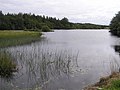
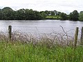
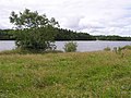
English: Assaroe Lake is a 1,100 acre artificial lake created by the Cathleen Falls and Cliff Hydro schemes and is controlled by the E.S.B., the Irish electricity board. The lake was created in 1957.
Media in category "Assaroe Lake"
The following 15 files are in this category, out of 15 total.
-
 Assaroe Lake - geograph.org.uk - 504734.jpg 640 × 479; 53 KB
-
 Assaroe Lake - geograph.org.uk - 504766.jpg 640 × 479; 46 KB
-
 Assaroe Lake at Corlea - geograph.org.uk - 504720.jpg 640 × 479; 79 KB
-
 Assaroe Lake at Knader - geograph.org.uk - 504750.jpg 640 × 478; 64 KB
-
 Assaroe Lake at Mullans - geograph.org.uk - 504729.jpg 640 × 479; 71 KB
-
 Assaroe Lake at Mullans - geograph.org.uk - 504733.jpg 640 × 478; 60 KB
-
 Assaroe Lake at Mullans - geograph.org.uk - 504738.jpg 640 × 479; 62 KB
-
 Assaroe Lake at Mullans - geograph.org.uk - 504741.jpg 640 × 479; 63 KB
-
 Assaroe Lake at Mullans - geograph.org.uk - 504746.jpg 640 × 479; 52 KB
-
 Assaroe Lake, Corlea - geograph.org.uk - 504718.jpg 640 × 479; 66 KB
-
 Boating on Assaroe lake, Ballyshannon - geograph.org.uk - 504773.jpg 640 × 479; 67 KB
-
 Fishing at Assaroe Lake - geograph.org.uk - 504737.jpg 640 × 479; 73 KB
-
 Lake Assaroe in the Rain - geograph.org.uk - 943744.jpg 640 × 480; 87 KB
-
 Lake Assaroe, Sam's Island and Horses - geograph.org.uk - 943727.jpg 480 × 640; 108 KB
-
 Mullans Townland - geograph.org.uk - 504732.jpg 640 × 479; 68 KB


