Category:Asserstraat 87 (Zuidvelde)
Jump to navigation
Jump to search
| Object location | | View all coordinates using: OpenStreetMap |
|---|
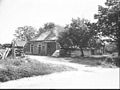
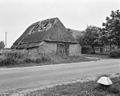
farmhouse in Noordenveld, Netherlands  | |||||
| Upload media | |||||
| Instance of | |||||
|---|---|---|---|---|---|
| Location | Zuidvelde, Noordenveld, Drenthe, Netherlands | ||||
| Street address |
| ||||
| Located on street |
| ||||
| Heritage designation |
| ||||
 | |||||
|
This is a category about rijksmonument number 30812
|
| Address |
|
Media in category "Asserstraat 87 (Zuidvelde)"
The following 7 files are in this category, out of 7 total.
-
 Achter- en zijgevel nr. F 288-24 - Zuidvelde - 20491347 - RCE.jpg 1,200 × 900; 130 KB
-
 Asserstraat 87.jpg 4,608 × 3,456; 3.43 MB
-
 Exterieur - Zuidvelde - 20225825 - RCE.jpg 1,200 × 963; 381 KB
-
 Exterieur - Zuidvelde - 20225826 - RCE.jpg 1,200 × 961; 289 KB
-
 Zij- en achtergevel nr. F 288-23 - Zuidvelde - 20491348 - RCE.jpg 1,200 × 900; 130 KB
-
 Zij- en voorgevel nr. F 288-25 - Zuidvelde - 20491346 - RCE.jpg 1,200 × 900; 180 KB
-
 Zij- en voorgevel nr. F 288-26 - Zuidvelde - 20491345 - RCE.jpg 1,200 × 900; 175 KB


