Category:Automobiles in West Yorkshire
Jump to navigation
Jump to search
Ceremonial counties of England: Bedfordshire · Berkshire · Buckinghamshire · Cambridgeshire · Cheshire · Cornwall · Cumbria · Derbyshire · Devon · Dorset · Durham · East Riding of Yorkshire · East Sussex · Essex · Gloucestershire · Greater London · Greater Manchester · Hampshire · Herefordshire · Hertfordshire · Isle of Wight · Kent · Lancashire · Leicestershire · Lincolnshire · Merseyside · Norfolk · North Yorkshire · Northamptonshire · Northumberland · Nottinghamshire · Oxfordshire · Shropshire · Somerset · South Yorkshire · Staffordshire · Suffolk · Surrey · Tyne and Wear · Warwickshire · West Midlands · West Sussex · West Yorkshire · Wiltshire · Worcestershire
City-counties: City of London
Former historic counties:
Other former counties:
City-counties: City of London
Former historic counties:
Other former counties:
Subcategories
This category has the following 8 subcategories, out of 8 total.
+
A
H
Media in category "Automobiles in West Yorkshire"
The following 60 files are in this category, out of 60 total.
-
 1970 Volkswagen Beetle seen in Queensbury, Bradford, West Yorkshire (20th June 2013).jpg 2,827 × 2,262; 4.4 MB
-
 48HYM at Saltaire (Taken by Flickr user 12th Jamuary 2013).jpg 3,520 × 2,514; 6.37 MB
-
 A65 through Yeadon - geograph.org.uk - 12105.jpg 640 × 480; 139 KB
-
 Ackworth Carnival - geograph.org.uk - 993174.jpg 640 × 350; 90 KB
-
 All Saints Parish Church, Halifax - geograph.org.uk - 1390345.jpg 640 × 480; 73 KB
-
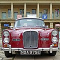 NDA 975E (8683223733).jpg 2,526 × 2,526; 4.42 MB
-
 Approaching Wakefield - geograph.org.uk - 367285.jpg 640 × 480; 78 KB
-

-
 Austin Cambridge on Main Street - geograph.org.uk - 5782663.jpg 1,024 × 683; 596 KB
-
 Back Briggate - Skipton Road - geograph.org.uk - 1514448.jpg 480 × 640; 72 KB
-
 Birdswell Avenue - Highmoor Crescent - geograph.org.uk - 3419449.jpg 640 × 480; 60 KB
-

-

-
 Bridge MVW2-182 - Cooper Bridge Road - geograph.org.uk - 762549.jpg 640 × 434; 59 KB
-
 Broomhill Avenue - Queen's Road - geograph.org.uk - 1350863.jpg 640 × 480; 263 KB
-
 Brunswick Street, Queensbury, 06.50 04.12.2008 (3082343501).jpg 2,560 × 1,920; 3.83 MB
-
 Bus garages, Swallow Street, Heckmondwike - geograph.org.uk - 6651766.jpg 2,000 × 1,266; 869 KB
-

-
 Classic cars at Fallwood Marina - geograph.org.uk - 4603039.jpg 1,024 × 768; 159 KB
-
 Eye-catcher on a car showroom - geograph.org.uk - 3704946.jpg 2,000 × 1,397; 781 KB
-
 Farnley Wood (38575615305).jpg 6,000 × 4,000; 7.8 MB
-
 Handel Street - Preston Street - geograph.org.uk - 2169378.jpg 640 × 480; 55 KB
-
 Hawthorn Drive, Rodley, Leeds - geograph.org.uk - 5109410.jpg 1,280 × 720; 560 KB
-
 Hawthorn Drive, Rodley, Leeds - geograph.org.uk - 5109412.jpg 1,280 × 720; 612 KB
-
 Infirmary Street - Lumb Lane - geograph.org.uk - 1042169.jpg 640 × 412; 180 KB
-
 Jowett Javelin (37097010314).jpg 4,896 × 3,672; 6.03 MB
-
 Jowett Javelin (37758652386).jpg 4,896 × 3,672; 6.17 MB
-
 Leeds Ring Road, Horsforth - geograph.org.uk - 129517.jpg 640 × 480; 63 KB
-
 Lytton Road - West Park Road - geograph.org.uk - 1067845.jpg 640 × 458; 251 KB
-
 Methley Drive - geograph.org.uk - 586557.jpg 640 × 434; 28 KB
-
 Midland Road - geograph.org.uk - 2085848.jpg 2,592 × 1,944; 702 KB
-
 Military vehicles on Main Street - geograph.org.uk - 5782666.jpg 1,024 × 683; 516 KB
-

-
 Mount Road - geograph.org.uk - 4089673.jpg 2,791 × 1,911; 1.61 MB
-
 Netherton Methodist Church and a hearse - geograph.org.uk - 6152258.jpg 3,563 × 4,738; 3.65 MB
-
 New industrial unit, Bradford - geograph.org.uk - 2474867.jpg 640 × 436; 77 KB
-
 Norcroft Street - Listerhills Road - geograph.org.uk - 1089855.jpg 640 × 424; 189 KB
-
 Panasonic Store - Darley Street - geograph.org.uk - 1533626.jpg 640 × 485; 98 KB
-
 Rebecca Street - St Thomas's Road - geograph.org.uk - 1042618.jpg 640 × 421; 177 KB
-
 Shipley (33799567773).jpg 6,000 × 4,000; 8.72 MB
-
 Shipley (33799630183).jpg 6,000 × 4,000; 8.94 MB
-
 Shipley (33799720973).jpg 6,000 × 4,000; 9.61 MB
-
 Skircoat Moor Road, Halifax - geograph.org.uk - 1823902.jpg 640 × 426; 114 KB
-
 Snowy Day on Calverley Lane - geograph.org.uk - 106578.jpg 640 × 480; 136 KB
-
 Spring Gardens - Manningham Lane - geograph.org.uk - 1041418.jpg 640 × 419; 209 KB
-
 Springfield Street - White Abbey Road - geograph.org.uk - 1042171.jpg 640 × 441; 227 KB
-
 St Jude's Place - Manningham Lane - geograph.org.uk - 1042140.jpg 640 × 453; 220 KB
-
 St Thomas's Road - Westgate - geograph.org.uk - 1042615.jpg 640 × 403; 197 KB
-
 The Grim Repair Man (2244262157).jpg 2,574 × 1,450; 2.57 MB
-
 The Guide Post Hotel - Common Road - geograph.org.uk - 1355131.jpg 640 × 437; 193 KB
-
 The post must get delivered - geograph.org.uk - 3118994.jpg 800 × 600; 271 KB
-
 Tour de France at Blackley - the Sky team car - geograph.org.uk - 4059016.jpg 2,048 × 1,536; 758 KB
-
 Tour de France, accordion player - geograph.org.uk - 4624702.jpg 1,024 × 768; 215 KB
-
 Vintage vehicles on Main Street - geograph.org.uk - 5782671.jpg 1,024 × 683; 584 KB
-
 Wedding transport - geograph.org.uk - 4208038.jpg 1,024 × 768; 182 KB
-
 Wing mirrors and bonnets - geograph.org.uk - 442393.jpg 640 × 427; 139 KB
-
 Woodhead Road - Horton Grange Road - geograph.org.uk - 1234980.jpg 640 × 480; 245 KB
-
 Woodside Road Track, Halifax - geograph.org.uk - 5396386.jpg 2,000 × 1,500; 1.17 MB
-
 Wynne Street - Westgate - geograph.org.uk - 1042612.jpg 640 × 406; 179 KB
-
 Lower Rushton Road - geograph.org.uk - 509714.jpg 640 × 408; 48 KB
.jpg)
.jpg)


.jpg)


.jpg)


.jpg)


.jpg)
.jpg)


.jpg)
.jpg)
.jpg)


.jpg)


