Category:Auwaiakeakua Bridge (Waikoloa, Hawaii)
Jump to navigation
Jump to search
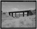
- Notes from HASB Survey number HAER HI-41: The 'Auwaiakeakua Bridge was constructed along the Mamalahoa Highway in 1940 by the Territory of Hawai'i to span the deep 'Auwaiakekua Gulch and its intermittent waterway. The project utilized Federal-aid funds allocated for the upgrading of the Hawai'i Island belt road system in the 1930s. The Mamalahoa Highway was the primary circum-island belt road until a new coastal road (the Queen Ka'ahumanu Highway) was completed in the 1970s. The bridge is a rare surviving example of a once common structural type - the timber stringer bridge - and typifies bridges built by the Territorial government in the immediate pre-World War II period. The bridge also represents the "work of a master"; William R. Bartels of the Territorial Highways Department. Bartels was responsible for the design of all major Territorial bridge projects between 1932 and his retirement from the department in 1956. The contractor, Otto Medeiros, built many other Federal-aid bridges on the island of Hawai'i.
| Object location | | View all coordinates using: OpenStreetMap |
|---|
Media in category "Auwaiakeakua Bridge (Waikoloa, Hawaii)"
The following 8 files are in this category, out of 8 total.