Category:Bank of Gage (Gage, Oklahoma)
Jump to navigation
Jump to search
| Object location | | View all coordinates using: OpenStreetMap |
|---|
_from_N_1.JPG) | |||||
| Upload media | |||||
| Instance of | |||||
|---|---|---|---|---|---|
| Location | Gage, Ellis County, Oklahoma | ||||
| Heritage designation |
| ||||
 | |||||
|
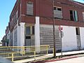
This is a category about a place or building that is listed on the National Register of Historic Places in the United States of America. Its reference number is 83004169. |
Media in category "Bank of Gage (Gage, Oklahoma)"
The following 8 files are in this category, out of 8 total.
-
 Bank of Gage (Oklahoma) from N 1.JPG 2,025 × 903; 347 KB
-
 Bank of Gage (Oklahoma) from NE 1.JPG 2,232 × 1,326; 499 KB
-
 Bank of Gage (Oklahoma) from NE 2.JPG 1,920 × 1,297; 435 KB
-
 Bank of Gage (Oklahoma) from NW 1.JPG 2,473 × 982; 443 KB
-
 Bank of Gage (Oklahoma) from NW 2.JPG 1,990 × 1,062; 490 KB
-
 Bank of Gage (Oklahoma) interior facing SW 1.JPG 2,559 × 1,919; 1.08 MB
-
 Bank of Gage (Oklahoma) location 1.JPG 2,533 × 1,899; 938 KB
-
 Bank of Gage (Oklahoma) vault door 1.JPG 1,335 × 1,819; 472 KB
_from_NE_1.JPG)
_from_NE_2.JPG)
_from_NW_2.JPG)
_interior_facing_SW_1.JPG)
_location_1.JPG)
_vault_door_1.JPG)
_from_NW_1.JPG)