Category:Bauernhaus Dorfstrasse 4 (Stettfurt)
Jump to navigation
Jump to search
| Object location | | View all coordinates using: OpenStreetMap |
|---|
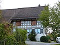
rural building in Stettfurt in the canton of Thurgau, Switzerland  | |||||
| Upload media | |||||
| Instance of | |||||
|---|---|---|---|---|---|
| Part of | |||||
| Location |
| ||||
| Street address |
| ||||
| Heritage designation |
| ||||
 | |||||
|
This is a category about a cultural property of regional significance in Switzerland with KGS number 11055
|
Media in category "Bauernhaus Dorfstrasse 4 (Stettfurt)"
The following 4 files are in this category, out of 4 total.
-
 Dorfstrasse 4 Stettfurt P1020675.jpg 4,000 × 3,000; 3.53 MB
-
 Dorfstrasse 4 Stettfurt P1020678.jpg 4,000 × 3,000; 3.42 MB
-
 Dorfstrasse 4 Stettfurt P1020680.jpg 4,000 × 3,000; 3.37 MB
-
 ETH-BIB-Stettfurt v. S. O. aus 300 m-Inlandflüge-LBS MH01-004010.tif 6,347 × 4,493; 81.7 MB

