Category:Bauernhaus Hell, Götzens
Jump to navigation
Jump to search
| Object location | | View all coordinates using: OpenStreetMap |
|---|
human settlement in Austria .JPG) | |||||
| Upload media | |||||
| Instance of | |||||
|---|---|---|---|---|---|
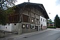
| Location | Götzens, Innsbruck-Land District, Tyrol, Austria | ||||
| Street address |
| ||||
| Heritage designation | |||||
 | |||||
Farm “The Light”.
| This category shows the protected monument with the number 38785 in Austria. (Commons, de, Wikidata) |
|
This category shows the remarkable cultural object in the Austrian state of Tyrol listed by the Tyrolean Art Cadastre with the ID
35640. (on tirisMaps, pdf, more images on Commons, Wikidata) |
Media in category "Bauernhaus Hell, Götzens"
The following 2 files are in this category, out of 2 total.
-
 Bauernhaus Hell (2).JPG 3,872 × 2,592; 4.2 MB
-
 Götzens-Bauernhaus Hell-20000809.jpg 3,032 × 2,088; 1.88 MB
