Category:Bay of Luka Telašćica
Jump to navigation
Jump to search
| Object location | | View all coordinates using: OpenStreetMap |
|---|
bay in Croatia  | |||||
| Upload media | |||||
| Instance of | |||||
|---|---|---|---|---|---|
| Located in protected area | |||||
| Location | Sali, Zadar County, Croatia | ||||
| Located in or next to body of water | |||||
| Length |
| ||||
 | |||||
Media in category "Bay of Luka Telašćica"
The following 14 files are in this category, out of 14 total.
-
 ARABIANA - panoramio.jpg 2,560 × 1,440; 1.85 MB
-
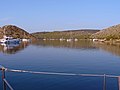
 Boats in the bay Mir, Luka Telašćica.jpg 2,144 × 1,424; 428 KB
-
 Dugi otok 0405-mod.jpg 1,130 × 712; 384 KB
-
 Dugi Otok, Naturpark Telašćica, Park prirode Telašćica - panoramio (2).jpg 3,072 × 2,304; 1.16 MB
-
 Gozdenjak island, Bay of Telaščica.jpg 600 × 300; 103 KB
-
 HLADNÉ ČAJKY - HUNGRY GULLS - panoramio.jpg 4,608 × 2,592; 4.94 MB
-
 KORNATI - panoramio.jpg 3,648 × 2,736; 2.38 MB
-
 Korotan and Galijola, Nature Park Telaščica.jpg 2,800 × 1,400; 1.9 MB
-
 Naturpark Telašćica, Park prirode Telašćica - panoramio.jpg 3,072 × 2,304; 793 KB
-
 OSTROVY MEDZI OSTROVMI - ISLANDS BETWEEN THE ISLANDS - panoramio.jpg 4,608 × 2,592; 5.37 MB
-
 Telascica - panoramio.jpg 2,816 × 2,112; 2.15 MB
-
 VODNÁ DIAĽNICA - WATER HIGHWAY - panoramio.jpg 4,608 × 2,592; 5.19 MB
-
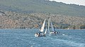
 Voilier à Kornati.jpg 2,144 × 1,424; 428 KB
-
 ZRAZIA SA^ - COLLIDE - panoramio.jpg 4,608 × 2,592; 5.88 MB


.jpg)


