Category:Binnenwijzend 78, Westwoud
Jump to navigation
Jump to search
| Object location | | View all coordinates using: OpenStreetMap |
|---|
 | |||||
| Upload media | |||||
| Instance of | |||||
|---|---|---|---|---|---|
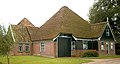
| Location | Westwoud, North Holland, Netherlands | ||||
| Street address |
| ||||
| Located on street |
| ||||
| Heritage designation |
| ||||
 | |||||
|
This is a category about rijksmonument number 14060
|
| Address |
|
Media in category "Binnenwijzend 78, Westwoud"
The following 6 files are in this category, out of 6 total.
-
 Aanzicht - Westwoud - 20035141 - RCE.jpg 1,200 × 809; 316 KB
-
 Binnenwijzend 78.jpg 1,462 × 776; 212 KB
-
 Deel zij- en voorgevel nr. EL 8 - Westwoud - 20480024 - RCE.jpg 1,200 × 900; 279 KB
-
 Voorgevel - Westwoud - 20035142 - RCE.jpg 1,200 × 799; 305 KB
-
 Voorgevel, gedeelte - Westwoud - 20035143 - RCE.jpg 1,200 × 801; 271 KB
-
 Zij- en voorgevel nr. EL 7 - Westwoud - 20480025 - RCE.jpg 1,200 × 900; 258 KB


