Category:Birchgrove, Swansea
Jump to navigation
Jump to search
village and community in Swansea  Eglwys Sant Ioan  | |||||
| Upload media | |||||
| Pronunciation audio | |||||
|---|---|---|---|---|---|
| Instance of | |||||
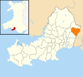
| Location | Swansea, Wales | ||||
| Population |
| ||||
| Area |
| ||||
 | |||||
Cymraeg: Cymuned a phentref yn ninas Abertawe yw Y Gellifedw (Saesneg: Birchgrove). Saif yng ngogledd-ddwyrain y sir, tua 6 millir o ganol Abertawe, fymryn i'r gogledd o draffordd yr M4, ac yn agos i'r ffîn gyda Castell-nedd Port Talbot. Mae'r gymuned yn cynnwys pentref Lôn-las a rhan o'r Glais yn ogystal a'r Gellifedw ei hun. Mae'r boblogaeth tua 6,500.
English: Birchgrove (population 6500 approx) is the name of a community and a large village in the City and County of Swansea, Wales. It does not have a community council. The village is situated roughly 6 miles from the centre of Swansea. It is situated roughly between the flood plain of the River Tawe and Drummau Mountain. Birchgrove also lies on the Neath Port Talbot border.
Media in category "Birchgrove, Swansea"
The following 105 files are in this category, out of 105 total.
-
 2010 Wales Swansea Community Birchgrove map.svg 512 × 472; 632 KB
-
 2024 Wales Swansea Community Birchgrove map.svg 512 × 472; 651 KB
-
 Ainon Baptist Chapel, Heol Las, Swansea - geograph.org.uk - 3807652.jpg 800 × 542; 132 KB
-
 Ainon chapelyard, Heol Las, Swansea - geograph.org.uk - 3807655.jpg 800 × 663; 170 KB
-
-
 Autofix, Llansamlet, Swansea - geograph.org.uk - 3761193.jpg 800 × 506; 121 KB
-
 Back Drive, Skewen - geograph.org.uk - 3761051.jpg 754 × 800; 208 KB
-
 Birchgrove Church Tower - geograph.org.uk - 3751710.jpg 480 × 640; 80 KB
-
 Birchgrove Comprehensive School - geograph.org.uk - 901475.jpg 640 × 467; 106 KB
-
 Birchgrove near Swansea - geograph.org.uk - 901405.jpg 640 × 480; 77 KB
-

-
 Birchgrove Road at The Bridgend Inn - geograph.org.uk - 3281942.jpg 640 × 481; 59 KB
-
 Birchgrove Road looking north - geograph.org.uk - 3281958.jpg 640 × 480; 58 KB
-
 Brecon Railway (Clydach) - geograph.org.uk - 4588113.jpg 1,200 × 1,600; 320 KB
-
 Bridge over eastbound on slip road of M4, junction 44 - geograph.org.uk - 5824576.jpg 1,600 × 1,197; 708 KB
-

-
 Bridges over the River Tawe - geograph.org.uk - 6178261.jpg 4,108 × 2,077; 3.25 MB
-
 Cae rygbi y Faerdre - Vardre rugby field - geograph.org.uk - 4415121.jpg 640 × 480; 109 KB
-

-
 Camlas Clydach Canal - geograph.org.uk - 3826506.jpg 640 × 426; 64 KB
-
 Drumau Road - geograph.org.uk - 5932764.jpg 2,448 × 3,264; 2.86 MB
-
 Drummau Road - geograph.org.uk - 5932765.jpg 2,448 × 3,264; 3.86 MB
-
 Eastern boundary of Swansea - geograph.org.uk - 3761071.jpg 800 × 570; 184 KB
-

-
 End of the road - geograph.org.uk - 1332680.jpg 480 × 640; 93 KB
-
 Engine House at Scotts Pit (geograph 2530994).jpg 1,200 × 1,600; 277 KB
-
 Entrance to Heol-las Farm, Swansea - geograph.org.uk - 3807128.jpg 800 × 636; 163 KB
-
 Farm Buildings, Birchgrove - geograph.org.uk - 831170.jpg 640 × 480; 304 KB
-
 Farm track - geograph.org.uk - 5932767.jpg 2,448 × 3,264; 2.99 MB
-
 Footpath, wall and copse on Mynydd Drumau - geograph.org.uk - 6216079.jpg 3,264 × 2,448; 1.82 MB
-

-
 Glan Brân - geograph.org.uk - 901560.jpg 640 × 475; 80 KB
-

-
 Heol Las - geograph.org.uk - 5298068.jpg 640 × 480; 95 KB
-
 Heol Las junction, Birchgrove - geograph.org.uk - 1240599.jpg 640 × 480; 89 KB
-
 Heol Las Park, Birchgrove - geograph.org.uk - 4111051.jpg 640 × 480; 92 KB
-
 Heol Las Park, Birchgrove. - geograph.org.uk - 1381072.jpg 640 × 480; 137 KB
-
 Heol Las. Swansea - geograph.org.uk - 3807098.jpg 800 × 645; 121 KB
-
 Heol Nant Bran houses, Swansea - geograph.org.uk - 3807104.jpg 800 × 696; 112 KB
-
 Heol Nant Bran, Swansea - geograph.org.uk - 3807100.jpg 800 × 557; 102 KB
-
 Herbert Thomas Way - geograph.org.uk - 6178239.jpg 6,139 × 2,977; 7.32 MB
-
 Junction 44 Motor Company, Swansea - geograph.org.uk - 3761184.jpg 800 × 532; 113 KB
-

-
 Llwybr ger Heol Las - Path near Heol Las - geograph.org.uk - 5298081.jpg 640 × 480; 119 KB
-
 M4 bridge over the River Tawe - geograph.org.uk - 6178250.jpg 3,264 × 2,448; 2.99 MB
-
 M4 eastbound at junction 44 - geograph.org.uk - 4349085.jpg 1,600 × 1,062; 398 KB
-
 M4 eastbound at junction 44 - geograph.org.uk - 4349102.jpg 1,600 × 1,062; 424 KB
-
 M4 eastbound towards junction 43 - geograph.org.uk - 4349105.jpg 1,600 × 1,062; 370 KB
-
 M4 eastbound towards junction 44 - geograph.org.uk - 4349093.jpg 1,600 × 1,062; 333 KB
-
 M4 junction 44 eastbound - geograph.org.uk - 3125402.jpg 640 × 425; 44 KB
-

-

-
 M4 west near Peniel Green - geograph.org.uk - 2935435.jpg 640 × 480; 45 KB
-

-
 M4, Junction 44 - geograph.org.uk - 3688645.jpg 640 × 430; 48 KB
-
 M4, Junction 44 - geograph.org.uk - 3688663.jpg 640 × 430; 52 KB
-
 M4, Junction 44 overbridge - geograph.org.uk - 3688662.jpg 640 × 430; 56 KB
-
 M4, railway bridge - geograph.org.uk - 3688666.jpg 640 × 402; 39 KB
-
 M4, westbound - geograph.org.uk - 3688665.jpg 640 × 430; 46 KB
-
 M4, westbound - geograph.org.uk - 3688667.jpg 640 × 401; 47 KB
-

-

-
 New Road, Heol Las, Swansea - geograph.org.uk - 3807660.jpg 800 × 688; 204 KB
-
 Oaktree Parc Clinic, Swansea - geograph.org.uk - 3761167.jpg 800 × 718; 290 KB
-
 One mile from junction 44 M4 - geograph.org.uk - 3125400.jpg 640 × 416; 51 KB
-
 Ordnance Survey Cut Mark - geograph.org.uk - 3713071.jpg 640 × 480; 84 KB
-
 Ordnance Survey Cut Mark - geograph.org.uk - 3942316.jpg 480 × 640; 131 KB
-
 Ordnance Survey Cut Mark - geograph.org.uk - 4642983.jpg 480 × 640; 110 KB
-
 Ordnance Survey Cut Mark - geograph.org.uk - 4642988.jpg 480 × 640; 107 KB
-
 Ordnance Survey Cut Mark - geograph.org.uk - 4838746.jpg 480 × 640; 109 KB
-
 Ordnance Survey Cut Mark - geograph.org.uk - 4838755.jpg 480 × 640; 113 KB
-
-
 Ordnance Survey Rivet - geograph.org.uk - 5789213.jpg 399 × 640; 98 KB
-
 Parc Bryn Heulog - geograph.org.uk - 5298060.jpg 640 × 480; 63 KB
-

-

-

-

-

-

-

-

-
 River and road - geograph.org.uk - 5932791.jpg 3,264 × 2,448; 2.26 MB
-
 Road Junction at Lon Las - geograph.org.uk - 5869131.jpg 3,264 × 2,448; 2.23 MB
-
 Rural meets suburban - geograph.org.uk - 5932766.jpg 2,448 × 3,264; 2.72 MB
-
 Scott's Pit Engine House - geograph.org.uk - 3015079.jpg 1,944 × 2,592; 1.16 MB
-
 Scott's Pit, Birchgrove, Swansea - geograph.org.uk - 55499.jpg 640 × 480; 87 KB
-
 Scott’s Pit - geograph.org.uk - 6178226.jpg 2,448 × 3,264; 3.74 MB
-
 Smiths Road, Birchgrove, Swansea - geograph.org.uk - 3807094.jpg 800 × 652; 146 KB
-
-
 Stream, Coed Glanbran - geograph.org.uk - 1240611.jpg 480 × 640; 142 KB
-
 Swansea , M4 Motorway - geograph.org.uk - 3926777.jpg 4,288 × 2,848; 3.73 MB
-
 Swansea , M4 Motorway - geograph.org.uk - 3927290.jpg 4,288 × 2,848; 5.34 MB
-
 Swansea , M4 Motorway - geograph.org.uk - 3927292.jpg 4,288 × 2,848; 5.14 MB
-
 Swansea , M4 Motorway - geograph.org.uk - 3927293.jpg 2,859 × 1,899; 3 MB
-
 Swansea , M4 Motorway - geograph.org.uk - 3927297.jpg 4,288 × 2,848; 5.34 MB
-

-
 Tawe River - geograph.org.uk - 5932799.jpg 3,264 × 2,448; 2.58 MB
-
 The Bowen, Swansea - geograph.org.uk - 3761060.jpg 800 × 741; 173 KB
-
 The Globe Inn - geograph.org.uk - 5932769.jpg 3,115 × 2,336; 2.09 MB
-

-
 Viewing stand - or bus stop shelter^ - geograph.org.uk - 1445541.jpg 640 × 480; 81 KB
-
 Welcome to Swansea, M4 - geograph.org.uk - 3688644.jpg 640 × 469; 53 KB
-

-
 Ynysallan Road, Swansea - geograph.org.uk - 3807709.jpg 800 × 625; 144 KB


_-_geograph.org.uk_-_4588113.jpg)


.jpg)


_at_Junction_44_-_geograph.org.uk_-_948542.jpg)


_-_geograph.org.uk_-_4653267.jpg)


