Category:Bloemstraat 42, Amsterdam
Jump to navigation
Jump to search
| Object location | | View all coordinates using: OpenStreetMap |
|---|
 | |||||
| Upload media | |||||
| Instance of |
| ||||
|---|---|---|---|---|---|
| Location | Amsterdam, North Holland, Netherlands | ||||
| Street address |
| ||||
| Located on street | |||||
| Heritage designation |
| ||||
 | |||||
|
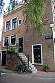
This is a category about rijksmonument number 605
|
| Address |
|
Media in category "Bloemstraat 42, Amsterdam"
The following 16 files are in this category, out of 16 total.
-
 2140 A-Bloemstr42 01 rm605.jpg 3,533 × 2,365; 7.07 MB
-
 2141 A-Bloemstr42 02 rm605.jpg 2,592 × 3,872; 9.07 MB
-
 2142 A-Bloemstr42 03 rm605.jpg 2,592 × 3,872; 9.34 MB
-
 Bloemstraat 40 and 42 corner with Eerste Bloemdwarsstraat.jpg 1,728 × 2,304; 1.28 MB
-
 Bloemstraat 42 corner with Eerste Bloemdwarsstraat.jpg 1,728 × 2,304; 1.2 MB
-
 Bloemstraat 42 detail 1.jpg 2,304 × 1,728; 760 KB
-
 Bloemstraat 42 detail 2.jpg 1,728 × 2,304; 826 KB
-
 Bloemstraat 42 detail 3.jpg 1,728 × 2,304; 718 KB
-
 Bloemstraat 42 detail 4.jpg 1,728 × 2,304; 770 KB
-
 Bloemstraat 42 door from Bloemstraat.jpg 2,304 × 1,728; 1.01 MB
-
 Bloemstraat 42 doors 1 from Eerste Bloemdwarsstraat.jpg 2,304 × 1,728; 1.48 MB
-
 Bloemstraat 42 doors 2 from Eerste Bloemdwarsstraat.jpg 1,728 × 2,304; 1.12 MB
-
 Bloemstraat 42 doors 3 from Eerste Bloemdwarsstraat.jpg 2,304 × 1,728; 922 KB
-
 Bloemstraat 42 top from Bloemstraat.jpg 1,728 × 2,304; 857 KB
-
 Bloemstraat 42 top from Eerste Bloemdwarsstraat.jpg 2,304 × 1,728; 1.17 MB
-
 Overzicht hoek Nieuwe Leliestraat - Amsterdam - 20016131 - RCE.jpg 1,198 × 1,200; 341 KB


