Category:Brislington East (ward)
Jump to navigation
Jump to search
electoral ward of the unitary authority of Bristol  | |||||
| Upload media | |||||
| Instance of |
| ||||
|---|---|---|---|---|---|
| Location | City of Bristol, South West England, England | ||||
 | |||||
Subcategories
This category has the following 3 subcategories, out of 3 total.
Media in category "Brislington East (ward)"
The following 99 files are in this category, out of 99 total.
-
 A seat by the Avon - geograph.org.uk - 5686789.jpg 2,304 × 1,704; 1.61 MB
-
 A sign awaiting Spring - geograph.org.uk - 5686841.jpg 1,704 × 2,304; 1.9 MB
-
 A surprisingly long drop to the river - geograph.org.uk - 5685833.jpg 2,304 × 1,704; 1.77 MB
-
 Avon Panorama - geograph.org.uk - 5556036.jpg 3,968 × 2,976; 3.55 MB
-
 Avon River Path - geograph.org.uk - 5561228.jpg 2,592 × 1,944; 1.09 MB
-
 Avon Valley Path - geograph.org.uk - 5561219.jpg 2,592 × 1,944; 1.51 MB
-
 Avon Valley Path - geograph.org.uk - 5562121.jpg 2,592 × 1,944; 1.3 MB
-
 Avon Valley tree blossom - geograph.org.uk - 5561195.jpg 2,592 × 1,944; 827 KB
-

-
 Boat trip docking at Beeses Bristol - geograph.org.uk - 5561213.jpg 2,592 × 1,944; 859 KB
-
 Boundary stone on the run down to Hicks Gate roundabout - geograph.org.uk - 5686888.jpg 1,704 × 2,304; 2.18 MB
-
 Brighton & Hove bus 91 (KPM 91E), 2011 Bristol Vintage Bus Group open day (1).jpg 4,592 × 3,056; 2.01 MB
-
 Brighton & Hove bus 91 (KPM 91E), 2011 Bristol Vintage Bus Group open day (2).jpg 4,592 × 3,056; 1.45 MB
-
 Brislington - Badgerline 5529 DHW351W.jpg 1,024 × 768; 362 KB
-
 Brislington - Brighton and Hove 91 KPM91E.jpg 1,024 × 768; 289 KB
-
 Brislington - Crosville DFG81 891VFM.jpg 1,024 × 1,024; 375 KB
-
 Brislington - Hants and Dorset 777 KLJ749.jpg 1,024 × 768; 356 KB
-
 Brislington - Newcomen engine house - geograph.org.uk - 6326764.jpg 472 × 640; 93 KB
-
 Brislington - Newcomen engine house - geograph.org.uk - 6326770.jpg 480 × 640; 59 KB
-
 Brislington - Newcomen engine house - geograph.org.uk - 6326775.jpg 480 × 640; 53 KB
-
 Brislington Bristol 2382 KHY383.jpg 1,024 × 768; 285 KB
-
 Brislington Bristol 2388 LHT911.jpg 1,024 × 768; 233 KB
-
 Brislington Bristol 461 AFB592V.jpg 1,024 × 768; 238 KB
-
 Brislington Bristol C3336 GHT154.jpg 768 × 1,024; 288 KB
-
 Brislington Bristol Tramways 2467 NAE3.jpg 1,024 × 768; 236 KB
-
 Brislington Brook - geograph.org.uk - 5560644.jpg 4,608 × 3,456; 4.7 MB
-
 Brislington BVBG - Royal Blue 1299 OTT98 and Bristol 2355 AHU803.jpg 2,048 × 1,536; 1.23 MB
-
 Brislington BVBG Bristol 2355 AHU803 near side.jpg 1,366 × 1,366; 502 KB
-
 Brislington BVBG Bristol 2355 AHU803 off side.jpg 1,024 × 768; 246 KB
-
 Brislington BVBG Bristol 3004 YHY80 undergoing restoration.jpg 1,024 × 768; 271 KB
-
 Brislington BVBG Bristol C3336 GHT154.jpg 1,366 × 1,366; 494 KB
-
 Brislington BVBG Hants and Dorset 779 KLJ749.jpg 1,024 × 768; 296 KB
-
 Brislington BVBG Western National 353 FTT704.jpg 1,366 × 1,366; 528 KB
-
 Brislington Crosville Motor Services LEU263P and L118YOD.jpg 1,024 × 768; 242 KB
-
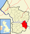
 Brislington East Bristol UK ward map.svg 1,138 × 1,266; 709 KB
-
 Brislington Hill.jpg 1,000 × 750; 790 KB
-
 Brislington Nightingale Valley - geograph.org.uk - 5560127.jpg 4,608 × 3,456; 5.15 MB
-
 Brislington West Yorkshire SMA5 811BWR.jpg 1,024 × 768; 228 KB
-
 Brislington Western National 3307 AFJ727T.jpg 1,024 × 768; 266 KB
-
 Brislington Western National 603 675COD.jpg 1,024 × 768; 253 KB
-
 Brislingtonurc.jpg 640 × 480; 90 KB
-
 Bristol Beeses restaurant - geograph.org.uk - 5560658.jpg 4,608 × 3,456; 3.51 MB
-
 Bristol brislington.png 702 × 780; 149 KB
-
 Bristol MMB «81 St Anne's Park.jpg 1,600 × 2,400; 2.79 MB
-
 Bristol MMB «82 St Anne's Park.jpg 2,400 × 1,600; 2.76 MB
-
 Bristol MMB «83 St Anne's Park.jpg 1,600 × 2,400; 2.77 MB
-
 Bristol MMB «84 St Anne's Park.jpg 1,600 × 2,400; 3.02 MB
-
 Coinham Ferry - geograph.org.uk - 5559257.jpg 4,608 × 3,456; 7.55 MB
-
 Conham Avon Valley - geograph.org.uk - 5556672.jpg 3,968 × 2,976; 3.06 MB
-
 Conham ferry - geograph.org.uk - 5559263.jpg 3,456 × 4,608; 4.28 MB
-
 Conham ferry - geograph.org.uk - 5559273.jpg 4,423 × 3,317; 4.24 MB
-
 Conham ferry - geograph.org.uk - 5559277.jpg 4,529 × 3,397; 3.79 MB
-
 Couch's Rank - geograph.org.uk - 5686802.jpg 2,304 × 1,704; 1.65 MB
-
 Eastwood Farm barn - geograph.org.uk - 5557955.jpg 4,608 × 3,456; 3.29 MB
-
 Eastwood Farm Ma Beeses - geograph.org.uk - 5557960.jpg 867 × 557; 127 KB
-
 Eastwood Farm open space - geograph.org.uk - 5557969.jpg 4,608 × 3,456; 5.57 MB
-
 Eastwood Farm open space - geograph.org.uk - 5559268.jpg 4,597 × 3,447; 4.34 MB
-
 Eastwood Farm open space - geograph.org.uk - 5559281.jpg 640 × 480; 115 KB
-
 Eastwood Farm open space - geograph.org.uk - 5559285.jpg 4,425 × 3,319; 4.45 MB
-
 Eastwood Farm open space - geograph.org.uk - 5561205.jpg 2,592 × 1,944; 829 KB
-
 Eastwood Farm open space Bristol - geograph.org.uk - 5559288.jpg 4,608 × 3,456; 3.64 MB
-
 Eastwood Farm open space Bristol - geograph.org.uk - 5559290.jpg 4,608 × 3,456; 3.4 MB
-
 Eastwood Farm open space Bristol - geograph.org.uk - 5559292.jpg 4,608 × 3,456; 3.75 MB
-
 Eastwood Farm open space Bristol - geograph.org.uk - 5560118.jpg 4,608 × 3,456; 3.35 MB
-
 Eastwood Farm open space Bristol - geograph.org.uk - 5560121.jpg 4,608 × 3,456; 4.44 MB
-
 Eastwood Farm open space Bristol - geograph.org.uk - 5560651.jpg 4,608 × 3,456; 6.19 MB
-
 Edna Avenue - geograph.org.uk - 6078934.jpg 2,048 × 1,536; 930 KB
-
 Feederbridge.jpg 640 × 424; 71 KB
-
 Fresh seating - geograph.org.uk - 5686853.jpg 2,304 × 1,704; 1.61 MB
-
 GWR arches, below Conham Ferry - geograph.org.uk - 181452.jpg 640 × 409; 102 KB
-
 GWR embankment below Brislington - geograph.org.uk - 181417.jpg 640 × 424; 121 KB
-
 Hanham Avon Valley - geograph.org.uk - 5556641.jpg 3,968 × 2,976; 3.5 MB
-
 Hanham Avon valley - geograph.org.uk - 5556645.jpg 3,968 × 2,976; 2.12 MB
-
 Hanham Avon valley - geograph.org.uk - 5556649.jpg 2,592 × 1,944; 1.07 MB
-
 Hannahmoreblueplaque.JPG 639 × 723; 214 KB
-

-
 Kennet ^ Avon Canal Walk - geograph.org.uk - 6051823.jpg 640 × 480; 106 KB
-
 Kennet ^ Avon Canal Walk - geograph.org.uk - 6051828.jpg 640 × 480; 110 KB
-
 Kennet ^ Avon Canal Walk - geograph.org.uk - 6051846.jpg 640 × 480; 133 KB
-
 Kennet ^ Avon Canal Walk - geograph.org.uk - 6051947.jpg 640 × 480; 90 KB
-
 Mooring post on the Avon towpath - geograph.org.uk - 5686849.jpg 1,704 × 2,304; 1.98 MB
-
 Norahcooke-hurleblueplaque.JPG 1,755 × 1,562; 957 KB
-
 Old Boat House, Birch Wood, St Anne's - geograph.org.uk - 5637299.jpg 5,184 × 2,920; 5.8 MB
-
 R Avon at Hencliff Wood, Conham - geograph.org.uk - 5637297.jpg 5,184 × 2,920; 4.92 MB
-
 Railway line at St Annes Bristol - geograph.org.uk - 5560995.jpg 4,608 × 3,456; 5.76 MB
-
 River Avon - geograph.org.uk - 5557963.jpg 998 × 643; 188 KB
-
 River Avon - geograph.org.uk - 5557973.jpg 1,003 × 643; 227 KB
-
 River Avon Bristol - geograph.org.uk - 5560119.jpg 4,475 × 3,355; 3.36 MB
-
 Riverside Cottages below The Batch, Hanham - geograph.org.uk - 5637295.jpg 5,184 × 2,920; 4.53 MB
-
 Riveting road - geograph.org.uk - 5686869.jpg 1,704 × 2,304; 1.82 MB
-
 Rugged footwear should be worn - geograph.org.uk - 5686846.jpg 1,704 × 2,304; 1.98 MB
-
 Simonstone Motor Group - geograph.org.uk - 6238564.jpg 3,469 × 2,189; 1.16 MB
-
 St Anne's Well, Bristol.jpg 640 × 428; 132 KB
-
 St Annes Park railway station MMB 03 43XXX.jpg 1,600 × 2,400; 799 KB
-
 St Annes Park railway station MMB 04 43XXX.jpg 1,564 × 2,337; 867 KB
-
 Subway cafe on Bath Road, Brislington - geograph.org.uk - 6238563.jpg 4,000 × 3,000; 2.41 MB
-
 The Avon from the A4174 - geograph.org.uk - 5685839.jpg 2,304 × 1,704; 1.76 MB
-
 The River Avon from Avon Bridge - geograph.org.uk - 1878426.jpg 1,500 × 993; 149 KB
-
 Where the councils change - geograph.org.uk - 5686892.jpg 2,304 × 1,704; 1.64 MB


_-_geograph.org.uk_-_5663888.jpg)


,_2011_Bristol_Vintage_Bus_Group_open_day_(1).jpg)
,_2011_Bristol_Vintage_Bus_Group_open_day_(2).jpg)


