Category:Brome Hall
Jump to navigation
Jump to search
| Object location | | View all coordinates using: OpenStreetMap |
|---|
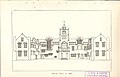
English country house in Suffolk, demolished 1958  _Eye,_Published_1947_cropped_to_show_Brome_and_Brome_Hall.png) | |||||
| Upload media | |||||
| Instance of | |||||
|---|---|---|---|---|---|
| Location |
| ||||
| Commissioned by |
| ||||
| Inception |
| ||||
| Dissolved, abolished or demolished date |
| ||||
 | |||||
Brome Hall was demolished in 1958 due to dereliction.
- Beckett, Matthew. Brome Hall. LOST HERITAGE / England's lost country houses. Retrieved on 4 May 2020.
Media in category "Brome Hall"
The following 13 files are in this category, out of 13 total.
-
 Brome Hall 01.jpg 3,296 × 2,128; 2.67 MB
-
 Brome Hall 02.jpg 3,296 × 2,128; 1.22 MB
-
 Brome Hall 03.jpg 3,296 × 2,128; 3.03 MB
-
 Gardens Old and New Vol 1 Brome Hall from the south-west 0287.jpg 4,906 × 3,259; 2.93 MB
-
 Gardens Old and New Vol 1 Brome Hall garden 0283.jpg 3,084 × 2,387; 1.67 MB
-
 Gardens Old and New Vol 1 Brome Hall garden 0286.jpg 2,968 × 2,338; 1.93 MB
-
 Gardens Old and New Vol 1 Brome Hall the terrace walk 0284.jpg 2,163 × 1,436; 559 KB
-
 Gardens Old and New Vol 1 Brome Hall verdant arches 0285.jpg 4,906 × 3,259; 3.39 MB
-
 Gardens Old and New Vol 1 Brome Hall view from the terrace 0286.jpg 2,199 × 1,785; 1.01 MB
-
 Gardens Old and New Vol 1 Brome Hall water lilies 0284.jpg 2,974 × 1,959; 1.61 MB
-
 Nathaniel Bacon The artist’s wife, Jane Bacon, Lady Cornwallis, née Meautys.jpeg 1,200 × 1,665; 756 KB
-

-
 Ordnance Survey Sheet TM 17 (62 17) Eye, Published 1947.png 7,632 × 9,748; 89 MB


_Eye,_Published_1947.png)