Category:Brook Vale bridge, Litherland
Jump to navigation
Jump to search
| Object location | | View all coordinates using: OpenStreetMap |
|---|
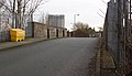
Bridge HXS3/29 carries Brook Vale at Sandy Road, Litherland, over the Northern Line of Merseyrail. It is 4.77 miles from the datum at Liverpool Exchange.
Media in category "Brook Vale bridge, Litherland"
The following 8 files are in this category, out of 8 total.
-
 Brook Vale bridge, Litherland 1.jpg 4,965 × 3,193; 23 MB
-
 Brook Vale bridge, Litherland 2.jpg 5,079 × 3,040; 18.74 MB
-
 Brook Vale bridge, Litherland 3.jpg 4,968 × 2,969; 19.99 MB
-
 Brook Vale bridge, Litherland 4.jpg 5,128 × 2,959; 19.6 MB
-
 Brook Vale bridge, Litherland 5.jpg 5,155 × 3,399; 22.29 MB
-
 Route board at Brook Vale bridge, Litherland.jpg 3,268 × 4,369; 16.51 MB
-
 View northwest from Brook Vale bridge, Litherland.jpg 3,358 × 5,041; 20.07 MB
-
 View southeast from Brook Vale bridge, Litherland.jpg 3,398 × 4,709; 17.32 MB


