Category:Burg. Brouwersstraat 14 (Garnwerd)
Jump to navigation
Jump to search
| Object location | | View all coordinates using: OpenStreetMap |
|---|
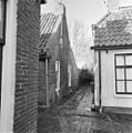
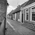
house in Winsum, Netherlands  | |||||
| Upload media | |||||
| Instance of | |||||
|---|---|---|---|---|---|
| Location | Garnwerd, Het Hogeland, Groningen, Netherlands | ||||
| Located on street | |||||
| Heritage designation |
| ||||
 | |||||
|
This is a category about rijksmonument number 15566
|
| Address |
|
Media in category "Burg. Brouwersstraat 14 (Garnwerd)"
The following 4 files are in this category, out of 4 total.
-
 Exterieur OVERZICHT NAAR HET NOORDEN - Garnwerd - 20280876 - RCE.jpg 1,193 × 1,200; 314 KB
-
 Exterieur OVERZICHT VANUIT HET WESTEN - Garnwerd - 20280843 - RCE.jpg 1,195 × 1,200; 353 KB
-
 Garnwerd - Burgemeester Brouwersstraat 14.jpg 4,000 × 3,000; 3.93 MB
-
 Voorgevel - Garnwerd - 20075211 - RCE.jpg 1,200 × 1,200; 270 KB


