Category:Burgbefestigung (Fronhof)
Jump to navigation
Jump to search
This is the category of the Bavarian Baudenkmal (cultural heritage monument) with the ID D-3-76-112-15 (Wikidata)
|
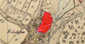
| Object location | | View all coordinates using: OpenStreetMap |
|---|
building in Altendorf, Upper Palatinate, Germany  | |||||
| Upload media | |||||
| Instance of | |||||
|---|---|---|---|---|---|
| Location | Altendorf, Schwandorf, Upper Palatinate, Bavaria, Germany | ||||
| Street address |
| ||||
| Heritage designation | |||||
 | |||||
[[Category:Fronhof (Altendorf)]|Burg]
Media in category "Burgbefestigung (Fronhof)"
The following 7 files are in this category, out of 7 total.
-
 FronhofBurgbefestigung 01.jpg 2,304 × 1,704; 860 KB
-
 FronhofBurgbefestigung 02.jpg 2,304 × 1,704; 910 KB
-
 FronhofBurgbefestigung 03.jpg 2,304 × 1,704; 756 KB
-
 FronhofBurgbefestigung 04.jpg 2,304 × 1,704; 914 KB
-
 FronhofBurgbefestigung 05.jpg 2,304 × 1,704; 929 KB
-
 FronhofBurgbefestigung 06.jpg 2,304 × 1,704; 928 KB
-
 Schloss Fronhof.PNG 553 × 291; 418 KB


