Category:Burgwal 68, Kampen
Jump to navigation
Jump to search
| Object location | | View all coordinates using: OpenStreetMap |
|---|
building in Kampen, Netherlands  | |||||
| Upload media | |||||
| Instance of | |||||
|---|---|---|---|---|---|
| Location | Kampen, Overijssel, Netherlands | ||||
| Heritage designation |
| ||||
 | |||||
|
This is a category about rijksmonument number 23018
|
| Address |
|
Media in category "Burgwal 68, Kampen"
The following 5 files are in this category, out of 5 total.
-
 Buitendeuren - Kampen - 20123071 - RCE.jpg 1,200 × 1,175; 267 KB
-
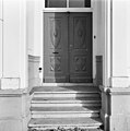 Deur voorgevel - Kampen - 20123073 - RCE.jpg 1,188 × 1,200; 191 KB
-
 Kampen - Burgwal 68-69.jpg 2,592 × 1,944; 1.65 MB
-
 Ramen - Kampen - 20123072 - RCE.jpg 1,200 × 1,200; 293 KB
-
 Voorgevels - Kampen - 20123070 - RCE.jpg 1,200 × 802; 189 KB


