Category:Bus maps of Kawasaki City Bus
Jump to navigation
Jump to search
English: Bus maps of Kawasaki City Bus
日本語: 川崎市交通局(川崎市バス)の経路図
Media in category "Bus maps of Kawasaki City Bus"
The following 16 files are in this category, out of 16 total.
-
 Bus map of Mizonokuchi - Kosugi.svg 512 × 456; 146 KB
-
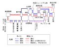 Bus map of Mizonokuchi - Kosugi20220327.svg 580 × 460; 155 KB
-
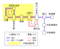 Bus map of Shiro11 and common ticket area.svg 446 × 358; 76 KB
-
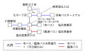
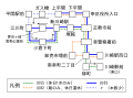
 Bus route map between Kawasaki Station and Toshiba Science Museum.png 459 × 807; 329 KB
-
 Kawa03 route map.svg 492 × 311; 96 KB
-
 Kawasaki City bus route map - Higashi-ogishima.svg 663 × 510; 200 KB
-
 Kawasaki City bus route map - Ikuta.svg 513 × 378; 104 KB
-
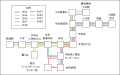
 Kawasaki City bus route map - Inukura.svg 875 × 395; 87 KB
-
 Kawasaki City bus route map - Kakio.svg 640 × 388; 111 KB
-
 Kawasaki City bus route map - Nishisuge.svg 386 × 261; 58 KB
-
 Kawasaki City bus route map - Ogura.svg 459 × 339; 115 KB
-
 Kawasaki City bus route map - Ogura20170326.svg 459 × 339; 82 KB
-
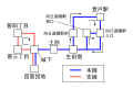
 Kawasaki City bus route map - Sinjo.svg 594 × 352; 93 KB
-
 Kawasaki City bus route map - Sinjo202004.svg 845 × 528; 82 KB
-
 Kawasaki City bus route map - Sinjo202202.svg 1,052 × 744; 78 KB
-
 Kawasaki City bus route map - Sinjo20220327.svg 1,052 × 744; 78 KB


