Category:Byker Wall
Jump to navigation
Jump to search
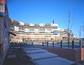
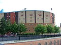
English: The Byker Wall is the name given to a long unbroken block of 620 maisonettes in the Byker district of Newcastle upon Tyne, England. The block was designed by the notable architect Ralph Erskine assisted by Vernon Gracie, and was built in the mid-1970s.
housing complex in North-East England  | |||||
| Upload media | |||||
| Instance of | |||||
|---|---|---|---|---|---|
| Location | Newcastle upon Tyne, Tyne and Wear, North East England, England | ||||
| Has part(s) |
| ||||
| Heritage designation | |||||
 | |||||
Subcategories
This category has the following 6 subcategories, out of 6 total.
Media in category "Byker Wall"
The following 33 files are in this category, out of 33 total.
-
 1 100-bn copy.jpg 6,600 × 5,100; 15.29 MB
-
 1 100-color copy.jpg 6,600 × 5,100; 16.12 MB
-
 1 200-bn00 copy.jpg 6,600 × 5,100; 6.83 MB
-
 1 200-color copy.jpg 6,600 × 5,100; 7.93 MB
-
 1 200-color copy2.jpg 6,600 × 5,100; 5.58 MB
-
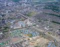 Aerial view of Byker, 1978 (26359478946).jpg 986 × 775; 333 KB
-
 Behind Byker Wall - geograph.org.uk - 1776427.jpg 1,024 × 768; 293 KB
-
 Behind the Byker Wall - geograph.org.uk - 1775411.jpg 8,178 × 3,846; 6.81 MB
-
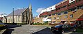 St Lawrence Church and Byker Crescent - geograph.org.uk - 1776451.jpg 1,600 × 662; 332 KB
-

-
 Byker Wall - geograph.org.uk - 933394.jpg 424 × 640; 80 KB
-
 Byker Wall and Tom Collins House - geograph.org.uk - 730923.jpg 640 × 480; 115 KB
-
 Byker Wall Erskine.jpg 2,721 × 1,938; 1.4 MB
-
 Byker Wall from Dalton Street - geograph.org.uk - 1776778.jpg 1,024 × 769; 188 KB
-
 Byker Wall, Newcastle upon Tyne (19584205179).jpg 943 × 730; 497 KB
-
 Byker, Newcastle, September 1970 cropped.jpg 845 × 544; 170 KB
-
 Cheviot Mount, Byker Wall - geograph.org.uk - 1776300.jpg 1,024 × 768; 232 KB
-
 Dalton Crescent, Byker Wall - geograph.org.uk - 1776332.jpg 768 × 1,024; 403 KB
-
 Dalton Crescent, Byker Wall - geograph.org.uk - 1776765.jpg 1,024 × 768; 331 KB
-
 Dunn Terrace, Byker Wall (detail) - geograph.org.uk - 1775530.jpg 769 × 1,024; 332 KB
-
 Erskine stadsdel Byker.jpg 2,901 × 2,223; 1.42 MB
-
 Gardens behind the Byker Wall - geograph.org.uk - 1776258.jpg 1,024 × 768; 271 KB
-
 Grace Street towards the Byker Wall - geograph.org.uk - 1776505.jpg 1,024 × 768; 241 KB
-
 Long Headlam, Byker Wall - geograph.org.uk - 1776246.jpg 1,024 × 768; 344 KB
-
 Long Headlam, south side of Byker Wall - geograph.org.uk - 1776413.jpg 768 × 1,024; 293 KB
-
 Pigeon lofts by the old railway - geograph.org.uk - 1776995.jpg 1,024 × 769; 326 KB
-
 Shipley Walk, Byker Wall - geograph.org.uk - 1775643.jpg 768 × 1,024; 383 KB
-
 The Byker Wall - geograph.org.uk - 1170115.jpg 640 × 480; 140 KB
-
 The Byker Wall - geograph.org.uk - 1635788.jpg 640 × 391; 70 KB
-
 The Byker Wall - geograph.org.uk - 53005.jpg 640 × 480; 107 KB
-
 The Byker Wall - geograph.org.uk - 566835.jpg 640 × 509; 93 KB
-
 View along the River Tyne from Byker, 1978 (26212524492).jpg 1,002 × 799; 287 KB
-
 Dunn Terrace - geograph.org.uk - 108525.jpg 640 × 480; 92 KB


.jpg)


.jpg)


_-_geograph.org.uk_-_1775530.jpg)


.jpg)
