Category:Cannon Mount, Birkenhead
Jump to navigation
Jump to search
| Object location | | View all coordinates using: OpenStreetMap |
|---|
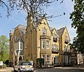
This is a category about listed building number 1291861. |
Grade II listed pair of houses in Birkenhead, Wirral, Merseyside, UK  | |||||
| Upload media | |||||
| Instance of |
| ||||
|---|---|---|---|---|---|
| Location | Birkenhead, Wirral, Merseyside, North West England, England | ||||
| Heritage designation |
| ||||
 | |||||
Grade II listed pair of 1863 houses divided into flats.
Media in category "Cannon Mount, Birkenhead"
The following 3 files are in this category, out of 3 total.
-
 Cannon Mount, Birkenhead (2).jpg 4,608 × 3,456; 4.08 MB
-
 Cannon Mount, Birkenhead 2019.jpg 4,020 × 3,429; 10.45 MB
-
 Datestone of Cannon Mount, Birkenhead.jpg 2,871 × 4,245; 9.16 MB
.jpg)
