Category:Castelo do Alandroal
Jump to navigation
Jump to search
Português: Castelo de Alandroal / Castelo e cerca urbana de Alandroal. Portugal, Évora, Alandroal, União das freguesias de Alandroal (Nossa Senhora da Conceição), São Brás dos Matos (Mina do Bugalho) e Juromenha (Nossa Senhora do Loreto)
|
This monument is classified as
Monumento Nacional .It is indexed in the IGESPAR database ( Instituto de Gestão do Património Arquitectónico e Arqueológico ), under the reference 70281.It is indexed in the SIPA database (Sistema de Informação para o Património Arquitectónico) under the reference 4360. |
| Object location | | View all coordinates using: OpenStreetMap |
|---|
building in Alandroal Municipality, Évora District, Portugal  | |||||
| Upload media | |||||
| Instance of | |||||
|---|---|---|---|---|---|
| Location | Nossa Senhora da Conceição, Alandroal (Nossa Senhora da Conceição), São Brás dos Matos (Mina do Bugalho) e Juromenha (Nossa Senhora do Loreto), Alandroal, Évora, Portugal | ||||
| Heritage designation | |||||
 | |||||
Subcategories
This category has only the following subcategory.
I
- Igreja Paroquial do Alandroal (14 F)
Pages in category "Castelo do Alandroal"
This category contains only the following page.
Media in category "Castelo do Alandroal"
The following 60 files are in this category, out of 60 total.
-
 Alandroal Castle, Alandroal, Portugal (PPL1-Corrected) julesvernex2.jpg 4,896 × 3,264; 3.86 MB
-
 Alandroal Castle, Alandroal, Portugal (PPL1-Corrected);Starburst effect julesvernex2.jpg 4,912 × 3,264; 2.69 MB
-
 Alandroal Castle, Alandroal, Portugal (PPL3-Altered) julesvernex2.jpg 4,397 × 3,240; 2.66 MB
-
 Alandroal December 2016-2.jpg 7,179 × 3,822; 16.64 MB
-
 Alandroal December 2016-4.jpg 7,360 × 4,034; 15.92 MB
-
 Alandroal, São Brás dos Matos e Juromenha - Castle of Alandroal - 20100609202112.jpg 9,869 × 3,015; 14.53 MB
-
 Alandroal, São Brás dos Matos e Juromenha - Castle of Alandroal - 20100612174348.jpg 1,772 × 1,181; 1.51 MB
-
 Alandroal, São Brás dos Matos e Juromenha - Castle of Alandroal - 20101017182457.jpg 4,518 × 3,012; 10.26 MB
-
 Alandroal, São Brás dos Matos e Juromenha - Castle of Alandroal - 20200829162937.jpg 3,968 × 2,976; 4.96 MB
-
 Alandroal, São Brás dos Matos e Juromenha - Castle of Alandroal - 20200829163730.jpg 4,608 × 3,456; 3.77 MB
-
 Alandroal, São Brás dos Matos e Juromenha - Castle of Alandroal - 20200829163816.jpg 4,608 × 3,456; 4.04 MB
-
 Alandroal, São Brás dos Matos e Juromenha - Castle of Alandroal - 20200829164028.jpg 4,608 × 3,456; 3.6 MB
-
 Alandroal, São Brás dos Matos e Juromenha - Castle of Alandroal - 20200829164044.jpg 4,608 × 3,456; 3.89 MB
-
 Alandroal, São Brás dos Matos e Juromenha - Castle of Alandroal - 20200829164058.jpg 4,608 × 3,456; 3.52 MB
-
 Alandroal, São Brás dos Matos e Juromenha - Castle of Alandroal - 20200829164110.jpg 3,456 × 4,608; 2.95 MB
-
 Alandroal, São Brás dos Matos e Juromenha - Castle of Alandroal - 20200829164148.jpg 4,608 × 3,456; 6.67 MB
-
 Alandroal, São Brás dos Matos e Juromenha - Castle of Alandroal - 20200829164312.jpg 3,968 × 2,976; 4.53 MB
-
 Alandroal, São Brás dos Matos e Juromenha - Castle of Alandroal - 20200829164338.jpg 4,608 × 3,456; 2.97 MB
-
 Alandroal, São Brás dos Matos e Juromenha - Castle of Alandroal - 20200829164750.jpg 3,456 × 4,608; 4.4 MB
-
 Alandroal, São Brás dos Matos e Juromenha - Castle of Alandroal - 20200829164825.jpg 2,976 × 3,968; 3.19 MB
-

-
 Castelo de Alandroal1214.jpg 1,952 × 2,608; 1.98 MB
-
 Castelo de Alandroal1215.jpg 1,952 × 2,608; 2.9 MB
-
 Castelo de Alandroal1216.jpg 2,608 × 1,952; 2.14 MB
-
 Castelo de Alandroal1217.jpg 1,952 × 2,608; 1.97 MB
-
 Castelo de Alandroal1218.jpg 2,608 × 1,952; 1.79 MB
-
 Castelo de Alandroal1219.jpg 1,952 × 2,608; 2.15 MB
-
 Castelo de Alandroal1220.jpg 2,608 × 1,952; 2.12 MB
-
 Castelo de Alandroal1221.jpg 2,608 × 1,952; 2.12 MB
-
 Castelo de Alandroal1222.jpg 2,608 × 1,952; 2.03 MB
-
 Castelo de Alandroal1223.jpg 2,608 × 1,952; 2.04 MB
-
 Castelo de Alandroal1224.jpg 2,608 × 1,952; 2.37 MB
-
 Castelo de Alandroal1225.jpg 2,608 × 1,952; 2.4 MB
-
 Castelo de Alandroal1226.jpg 2,608 × 1,952; 2.33 MB
-
 Castelo de Alandroal1227.jpg 1,952 × 2,608; 2.57 MB
-
 Castelo de Alandroal1228.jpg 1,952 × 2,608; 2.04 MB
-
 Castelo de Alandroal1229.jpg 1,952 × 2,608; 3.03 MB
-
 Castelo de Alandroal1231.jpg 2,608 × 1,952; 2.19 MB
-
 Castelo do Alandroal - Portugal (14437246759).jpg 2,465 × 3,696; 2.27 MB
-
 Castelo do Alandroal - Portugal (14437258629).jpg 3,828 × 2,552; 2.08 MB
-
 Castelo do Alandroal - Portugal (15183131668).jpg 3,888 × 2,592; 2.04 MB
-
 Castelo do Alandroal - Portugal (15183217277).jpg 3,888 × 2,592; 2.37 MB
-
 Castelo do Alandroal - Portugal (15346709116).jpg 3,888 × 2,592; 1.86 MB
-
 Castelo do Alandroal - Portugal (15644484987).jpg 3,828 × 2,552; 2.04 MB
-
 Castelo do Alandroal - Portugal (15827763061).jpg 2,526 × 3,790; 4.2 MB
-
 Castelo do Alandroal - Portugal (15829640595).jpg 2,592 × 3,888; 3.21 MB
-
 Castelo do Alandroal - Portugal (16475251429).jpg 2,532 × 3,798; 2.37 MB
-
 Castelo do Alandroal - Portugal (16660379692).jpg 2,592 × 3,888; 2.2 MB
-
 Castelo do Alandroal - Portugal (26802075282).jpg 2,552 × 3,828; 2.4 MB
-
 Castelo do Alandroal - vista do adarve e da torre da igreja paroquial.jpg 3,000 × 4,000; 6.86 MB
-
 Castelo do Alandroal - vista interior.jpg 3,000 × 4,000; 6.27 MB
-
 Castelo do Alandroal - vista praça de armas, da igreja paroquial e da torre de menagem.jpg 4,000 × 3,000; 7.69 MB
-
 Castelo do Alandroal 06.jpg 1,107 × 1,476; 942 KB
-
 Castelo do Alandroal, vista parcial da praça de armas.jpg 4,000 × 3,000; 7.47 MB
-
 Castelo e igreja matriz do Alandroal (Portugal).jpg 1,280 × 867; 255 KB
-
 Castle walls, Alandroal, Portugal julesvernex2.jpg 4,788 × 3,253; 5.97 MB
-
 Igreja e Castelo do Alandroal 01.jpg 1,860 × 1,395; 1.22 MB
-
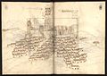 Livro das Fortalezas 20- Alandroal.jpg 3,047 × 2,168; 1.02 MB
-
 Super pordego en Alandroal.jpg 640 × 480; 278 KB
-
 Turo el Alandroal.jpg 480 × 640; 233 KB
_julesvernex2.jpg)
;Starburst_effect_julesvernex2.jpg)
_julesvernex2.jpg)


.jpg)
.jpg)
.jpg)
.jpg)
.jpg)
.jpg)
.jpg)
.jpg)
.jpg)
.jpg)
.jpg)


.jpg)


