Category:Château (Route du Vélodrome 1, Geneva)
Jump to navigation
Jump to search
| Object location | | View all coordinates using: OpenStreetMap |
|---|
 | |||||
| Upload media | |||||
| Instance of | |||||
|---|---|---|---|---|---|
| Part of | |||||
| Location |
| ||||
| Street address |
| ||||
| Heritage designation | |||||
 | |||||
Media in category "Château (Route du Vélodrome 1, Geneva)"
This category contains only the following file.
-
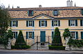 Chateau, Plan-les-Ouates.JPG 4,928 × 3,264; 5.48 MB