Category:Château de Montagny-les-Monts
Jump to navigation
Jump to search
| Object location | | View all coordinates using: OpenStreetMap |
|---|
castle ruins in Montagny-les-Monts in the canton of Fribourg, Switzerland  | |||||
| Upload media | |||||
| Instance of | |||||
|---|---|---|---|---|---|
| Part of | |||||
| Location | Montagny-les-Monts, Montagny, Broye District, Canton of Fribourg, Switzerland | ||||
| Street address |
| ||||
| Heritage designation | |||||
 | |||||
Media in category "Château de Montagny-les-Monts"
The following 9 files are in this category, out of 9 total.
-
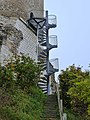 Burgruine Montagny-les-Monts Aussentreppe.jpg 6,936 × 9,248; 5.01 MB
-
 Burgruine Montagny-les-Monts Innentreppe.jpg 6,936 × 9,248; 3.93 MB
-
 Burgruine Montagny-les-Monts Plattform.jpg 9,248 × 6,936; 4.63 MB
-
 Burgruine Montagny-les-Monts.jpg 6,936 × 9,248; 4.32 MB
-
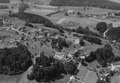 ETH-BIB-Montagny-les-Monts-LBS H1-025237.tif 8,308 × 5,743; 136.51 MB
-
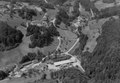
 ETH-BIB-Montagny-les-Monts-LBS H1-025247.tif 8,040 × 5,641; 129.76 MB
-
 ETH-BIB-Montagny-les-Monts-LBS H1-025259.tif 8,220 × 5,743; 135.11 MB
-
 ETH-BIB-Montagny-les-Monts-LBS H1-025276.tif 8,077 × 5,577; 128.92 MB
-
 Montagny-les-Monts 9365.jpg 3,888 × 2,592; 2.77 MB


