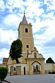
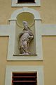
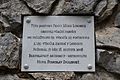
Category:Church of Saint Adalbert (Blatné)
Jump to navigation
Jump to search
| Object location | | View all coordinates using: OpenStreetMap |
|---|
Media in category "Church of Saint Adalbert (Blatné)"
The following 6 files are in this category, out of 6 total.
-
 Blatné kostol 01.jpg 2,304 × 3,456; 1.24 MB
-
 Blatné kostol 02.jpg 2,304 × 3,456; 1.27 MB
-
 Blatné kostol 03.jpg 2,304 × 3,456; 1.27 MB
-
 Blatné kostol 04.jpg 3,456 × 2,304; 1.23 MB
-
 Blatné kostol 06.jpg 3,456 × 2,304; 1.79 MB
-
 Blatné kostol 08.jpg 3,456 × 2,304; 1.71 MB


