Category:City walls in Kremnica
Jump to navigation
Jump to search
| Object location | | View all coordinates using: OpenStreetMap |
|---|
fortification in Kremnica, Slovakia  | |||||
| Upload media | |||||
| Instance of | |||||
|---|---|---|---|---|---|
| Location | Kremnica, Žiar nad Hronom District, Banská Bystrica Region, Slovakia | ||||
| Architectural style | |||||
| Heritage designation |
| ||||
| Inception |
| ||||
 | |||||
| This category shows the protected monument with the number 613-2271/1 (other) in the Slovak Republic. |
to
| This category shows the protected monument with the number 613-2271/8 (other) in the Slovak Republic. |
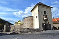
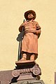
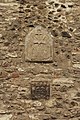
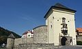
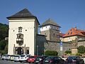
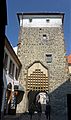
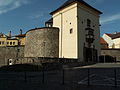
English: City fortifications of Kremnica, Slovakia. Built in the 15th century.
Media in category "City walls in Kremnica"
The following 41 files are in this category, out of 41 total.
-
 BarbakánKremnica.JPG 1,920 × 2,560; 1.48 MB
-
 Bašta parkanová.jpg 1,944 × 2,592; 790 KB
-
 Városkapu. Fortepan 23486.jpg 2,563 × 2,276; 2.72 MB
-
 Kremnica - Barbakán - detail 1.jpg 4,608 × 3,072; 3.52 MB
-
 Kremnica - Barbakán - detail 2.jpg 3,072 × 4,608; 3.48 MB
-
 Kremnica - Barbakán - detail 3.jpg 4,608 × 3,072; 3.51 MB
-
 Kremnica - Barbakán - detail 4.jpg 4,608 × 3,072; 3.66 MB
-
 Kremnica - bašta a veža.jpg 4,608 × 3,072; 3.59 MB
-
 Kremnica - bašta juhovýchodná (1).jpg 3,072 × 4,608; 3.46 MB
-
 Kremnica - bašta juhovýchodná.jpg 3,072 × 4,608; 3.48 MB
-
 Kremnica - Bašta juhozápadná.jpg 3,072 × 4,608; 3.48 MB
-
 Kremnica - Bránová veža, Dolná brána (1).jpg 3,072 × 4,608; 4.41 MB
-
 Kremnica - Bránová veža, Dolná brána (2).jpg 4,608 × 3,072; 3.46 MB
-
 Kremnica - Bránová veža, Dolná brána - detail 1.jpg 4,608 × 3,072; 3.52 MB
-
 Kremnica - Bránová veža, Dolná brána - detail 2.jpg 3,072 × 4,608; 3.46 MB
-
 Kremnica - Bránová veža, Dolná brána - detail 3.jpg 1,768 × 2,644; 1.18 MB
-
 Kremnica - Bránová veža, Dolná brána - detail 4.jpg 2,188 × 3,276; 1.59 MB
-
 Kremnica - Bránová veža, Dolná brána - detail 5.jpg 4,608 × 3,072; 3.48 MB
-
 Kremnica - Bránová veža, Dolná brána.jpg 3,072 × 4,608; 3.93 MB
-
 Kremnica - Dolná brána - Predsunutá veža.jpg 2,901 × 4,358; 2.86 MB
-
 Kremnica - Dom na hradbách.jpg 4,608 × 3,072; 3.49 MB
-
 Kremnica - dvor predsunutej veže, prejazd.jpg 4,234 × 2,825; 2.98 MB
-
 Kremnica - gate tower.JPG 1,944 × 2,592; 1.08 MB
-
 Kremnica pomnik SNP a Barbakan.jpg 800 × 600; 92 KB
-
 Kremnica, brána dolná (1).jpeg 2,976 × 3,968; 2.52 MB
-
 Kremnica, brána dolná (2).jpeg 2,976 × 3,968; 2.49 MB
-
 Kremnica, Dolní brána.jpg 3,000 × 4,000; 4.39 MB
-
 Kremnica-2.JPG 2,472 × 3,296; 1.05 MB
-
 Kremnica-3.JPG 2,472 × 3,296; 930 KB
-
 Kremnica2.jpg 3,456 × 5,184; 11.16 MB
-
 Körmöcbánya 1906.jpg 600 × 371; 52 KB
-
 Körmöcbánya22.JPG 1,728 × 2,304; 560 KB
-
 SK-Kremnica-Stadttor-01.jpg 3,769 × 2,230; 1.61 MB
-
 SK-Kremnica-Stadttor-02.jpg 1,981 × 2,641; 1.53 MB
-
 SK-Kremnica-Stadttor-03.jpg 2,548 × 1,911; 1.51 MB
-
 SK-Kremnica-Stadttor-04.jpg 3,014 × 2,170; 1.32 MB
-
 SK-Kremnica-Stadttor-05.jpg 2,614 × 4,419; 1.42 MB
-
 Veza branova kremnica.jpg 1,569 × 2,592; 394 KB
-
 Veza branova kremnica01.jpg 1,944 × 1,720; 308 KB
-
 Veža bránová.jpg 4,000 × 3,000; 5.57 MB
-
 Vstupnábrána.JPG 2,560 × 1,920; 1.87 MB


.jpg)


.jpg)
.jpg)


.jpeg)
.jpeg)


