Category:Clark Bridge (U.S. Route 67)
Jump to navigation
Jump to search
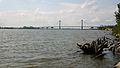
English: The current Clark Bridge carries U.S. Route 67 over the Mississippi River between Alton, Madison County, Illinois and West Alton, St. Charles County, Missouri in the USA. It is sometimes called the Super Bridge or Clark Superbridge, and was built in 1994, replacing the "old Clark Bridge".
| Object location | | View all coordinates using: OpenStreetMap |
|---|
cable-stayed bridge across the Mississippi River between West Alton, Missouri and Alton, Illinois  | |||||
| Upload media | |||||
| Instance of | |||||
|---|---|---|---|---|---|
| Location | |||||
| Crosses | |||||
| Carries | |||||
| Inception |
| ||||
| Date of official opening |
| ||||
| Length |
| ||||
 | |||||
Media in category "Clark Bridge (U.S. Route 67)"
The following 36 files are in this category, out of 36 total.
-
 004Alton.jpg 667 × 500; 193 KB
-
 2006-09-05 3000x1700 alton clark bridge.jpg 3,000 × 1,700; 478 KB
-
 20190828-AMS-PJK-1973 TONED (48670536008).jpg 6,084 × 4,056; 5.03 MB
-
 20190828-OSEC-PJK-1752 TONED (48670536608).jpg 6,717 × 4,478; 7.15 MB
-
 Aerial view of Alton Illinois during June 2008 flood.jpg 3,872 × 2,592; 4.54 MB
-
 Alton - Miss River Crossing.jpg 5,176 × 2,119; 1.47 MB
-
 Altonbridge.jpg 1,500 × 965; 750 KB
-
 AltonBruecke.JPG 1,344 × 855; 267 KB
-
 Bridge Deck P7100227.jpg 3,072 × 2,304; 1.04 MB
-
 Bridge Deck P7100230.jpg 3,072 × 2,304; 1.2 MB
-
 Bridge deck P7100231.jpg 3,072 × 2,304; 1.14 MB
-
 Bridge deck P7100232.jpg 3,072 × 2,304; 1.2 MB
-
 Bridge deck P7100233.jpg 3,072 × 2,304; 1.21 MB
-
 Clark Bridge (2-panel).jpg 2,605 × 1,125; 264 KB
-
 Clark Bridge (3-panel).jpg 3,863 × 1,111; 359 KB
-
 Clark Bridge (4-panel).jpg 5,057 × 1,105; 458 KB
-
 Clark Bridge (Alton, IL).jpg 5,145 × 2,135; 1.47 MB
-
 Clark Bridge at Alton, Illinois.jpg 1,674 × 2,166; 1.71 MB
-
 Clark Bridge from Melvin Price Locks.jpg 1,500 × 1,001; 540 KB
-
 Clark Bridge P7090029.jpg 3,072 × 2,304; 1.04 MB
-
 Clark Bridge P7090030.jpg 3,072 × 2,304; 1.06 MB
-
 Clark Bridge P7090045.jpg 3,072 × 2,304; 1.04 MB
-
 Clark Bridge P7090053.jpg 3,072 × 2,304; 1.02 MB
-
 Clark Bridge P7100172.jpg 3,072 × 2,304; 1.16 MB
-
 Clark Bridge P7100188.jpg 3,072 × 2,304; 1.02 MB
-
 Clark Bridge P7100193.JPG 2,304 × 3,072; 1.08 MB
-
 Clark Bridge P7100194.JPG 3,072 × 2,304; 1.18 MB
-
 Clark Bridge P7100206.jpg 3,072 × 2,304; 1.16 MB
-
 Clark Bridge P7100223.jpg 3,072 × 1,352; 365 KB
-
 Clark Bridge St. Louis.jpeg 1,348 × 1,011; 168 KB
-
 Clark bridge west alton mo dec 2009.jpg 1,800 × 1,215; 938 KB
-
 Clark Bridge, Alton, Illinois.jpg 2,041 × 2,041; 350 KB
-
 Distant View P7100187.jpg 3,072 × 2,304; 1.18 MB
-
 Towers P7100190.jpg 2,304 × 3,072; 1.19 MB
-
 Upstream view P7100218.jpg 3,072 × 2,304; 1.19 MB
-
 West Approach P7100228.jpg 3,072 × 2,304; 1.07 MB


.jpg)
.jpg)


.jpg)
.jpg)


.jpg)
.jpg)
Categories:
- Alton, Illinois
- Bridges in St. Charles County, Missouri
- U.S. Route 67 in Illinois
- U.S. Route 67 in Missouri
- Bridges over the Mississippi River in Illinois
- Bridges over the Mississippi River in Missouri
- Road bridges in Illinois
- Road bridges in Missouri
- Cable-stayed bridges in Illinois
- Cable-stayed bridges in Missouri
- Girder bridges in Illinois
- Girder bridges in Missouri
- 1990s bridges in Illinois
- 1990s bridges in Missouri
- Built in Illinois in 1994
- Built in Missouri in 1994
- Bridges in the United States completed in 1994
- Bridges over railway lines in Illinois
- Bridges on U.S. Route 67
- 1.4 kilometers bridges
- Cable-stayed fanform bridges